Geolocate

Ruaraka topographic map

Interactive map

Click on the map to display elevation.

About this map

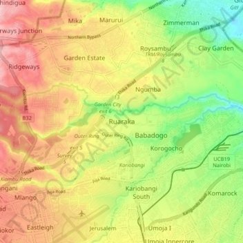
Name: Ruaraka topographic map, elevation, terrain.

Location: Ruaraka, Nairobi, Nairobi County, 00620, Kenya (-1.28299 36.83562 -1.20299 36.91562)

Average elevation: 5,302 ft

Minimum elevation: 5,030 ft

Maximum elevation: 5,558 ft

Other topographic maps

Click on a map to view its topography, its elevation and its terrain.

Kagondo

Kenya > Nairobi County > Nairobi

Kagondo, Nairobi, Nairobi County, 00109, Kenya

Average elevation: 6,224 ft

Nairobi Dam

Kenya > Nairobi County > Nairobi

Nairobi Dam, Siwaka Estate, Nairobi, Nairobi County, Kenya

Average elevation: 5,561 ft

Lake

Kenya > Nairobi County > Nairobi

Lake, Karen, Nairobi, Nairobi County, Kenya

Average elevation: 6,135 ft