
Applegate topographic map
Click on the map to display elevation.
About this map
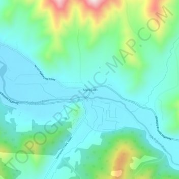
Name: Applegate topographic map, elevation, terrain.
Location: Applegate, Jackson County, Oregon, United States (42.23706 -123.18824 42.27706 -123.14824)
Average elevation: 1,644 ft
Minimum elevation: 1,214 ft
Maximum elevation: 3,087 ft
Jackson County trails, hiking, mountain biking, running and outdoor activities
Other topographic maps
Click on a map to view its topography, its elevation and its terrain.
Ashland
United States > Oregon > Jackson County
Ashland lies within Oregon's southwest interior climate zone, in which all but the higher-elevation sites are in the rain shadow of the Oregon Coast Range to the west. The largest urban areas in this zone in addition to Ashland are Medford and Grants Pass in the Rogue Valley, and Roseburg in the Umpqua River…
Average elevation: 2,539 ft
Central Point
United States > Oregon > Jackson County
The city lies at an elevation of about 1,272 feet (388 m) along Oregon Highway 99 and Interstate 5 northwest of Medford. Jacksonville is to the south and Gold Hill to the northwest. The Central Oregon and Pacific Railroad passes through Central Point.
Average elevation: 1,263 ft
Ashland
United States > Oregon > Jackson County
Ashland lies within Oregon's southwest interior climate zone, in which all but the higher-elevation sites are in the rain shadow of the Oregon Coast Range to the west. The largest urban areas in this zone in addition to Ashland are Medford and Grants Pass in the Rogue Valley, and Roseburg in the Umpqua River…
Average elevation: 2,539 ft