
Stump Lake topographic map
Click on the map to display elevation.
About this map
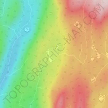
Name: Stump Lake topographic map, elevation, terrain.
Average elevation: 4,334 ft
Minimum elevation: 3,770 ft
Maximum elevation: 4,931 ft
Other topographic maps
Click on a map to view its topography, its elevation and its terrain.
Christian Valley
Canada > British Columbia > Regional District of Kootenay Boundary > Area E (Beaverdell/West Boundary)
Average elevation: 3,009 ft
Rock Creek
Canada > British Columbia > Regional District of Kootenay Boundary > Area E (Beaverdell/West Boundary)
Average elevation: 2,507 ft
Big White Mountain
Canada > British Columbia > Regional District of Kootenay Boundary > Area E (Beaverdell/West Boundary)
Average elevation: 6,759 ft
Mount Baldy
Canada > British Columbia > Regional District of Kootenay Boundary > Area E (Beaverdell/West Boundary)
Average elevation: 5,948 ft
Beaverdell
Canada > British Columbia > Regional District of Kootenay Boundary > Area E (Beaverdell/West Boundary)
Average elevation: 3,136 ft
Carmi
Canada > British Columbia > Regional District of Kootenay Boundary > Area E (Beaverdell/West Boundary)
Average elevation: 3,241 ft