Geolocate

Lindley topographic map

Click on the map to display elevation.

About this map

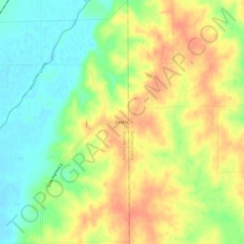
Name: Lindley topographic map, elevation, terrain.

Location: Lindley, Grundy County, Missouri, United States (40.06196 -93.38827 40.10196 -93.34827)

Average elevation: 850 ft

Minimum elevation: 768 ft

Maximum elevation: 922 ft

Grundy County trails, hiking, mountain biking, running and outdoor activities

Other topographic maps

Click on a map to view its topography, its elevation and its terrain.

Galt

United States > Missouri > Grundy County

Average elevation: 830 ft

Laredo

United States > Missouri > Grundy County

Average elevation: 801 ft

Tindall

United States > Missouri > Grundy County

Average elevation: 814 ft

Brimson

United States > Missouri > Grundy County

Average elevation: 797 ft

Gear up for your next adventure:

🧭Pro Hiking Compasses - High-accuracy liquid-filled compasses for topographic orientation
🧯Emergency Survival Kit - All‑in‑one survival essentials for the backcountry
🗺️NatGeo Topo Maps - High-quality waterproof printed topographic maps of US Parks
🖼️Topo Map Wall Art - Decorative topographic prints of famous peaks and regions
🔋Rechargeable Batteries - Power up your outdoor devices

As an Amazon Associate, this site earns from qualifying purchases at no extra cost to you.