Geolocate

Tindall topographic map

Click on the map to display elevation.

About this map

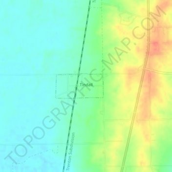
Name: Tindall topographic map, elevation, terrain.

Location: Tindall, Grundy County, Missouri, United States (40.15895 -93.61458 40.16286 -93.60475)

Average elevation: 814 ft

Minimum elevation: 751 ft

Maximum elevation: 922 ft

Grundy County trails, hiking, mountain biking, running and outdoor activities

Other topographic maps

Click on a map to view its topography, its elevation and its terrain.

Edinburg

United States > Missouri > Grundy County

Average elevation: 932 ft

Alpha

United States > Missouri > Grundy County

Average elevation: 797 ft

Buttsville

United States > Missouri > Grundy County

Average elevation: 873 ft

Dunlap

United States > Missouri > Grundy County

Average elevation: 856 ft

Hickory Creek

United States > Missouri > Grundy County

Average elevation: 801 ft

Lindley

United States > Missouri > Grundy County

Average elevation: 850 ft

Shott

United States > Missouri > Grundy County

Average elevation: 817 ft

Gear up for your next adventure:

🦶Carbon Trekking Poles - Reduce knee impact on steep descents with ultra-light poles
🗺️NatGeo Topo Maps - High-quality waterproof printed topographic maps of US Parks
🍳Camping Cook Set - Complete cookware for outdoor meals
👖Convertible Hiking Pants - Versatile zip-off pants for changing altitudes and temperatures
🛏️Cold Weather Sleeping Bag - Warm sleeping bag for cold conditions

As an Amazon Associate, this site earns from qualifying purchases at no extra cost to you.