Geolocate

Laredo topographic map

Click on the map to display elevation.

About this map

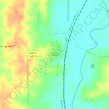
Name: Laredo topographic map, elevation, terrain.

Location: Laredo, Grundy County, Missouri, United States (40.02037 -93.45525 40.03102 -93.44276)

Average elevation: 801 ft

Minimum elevation: 741 ft

Maximum elevation: 889 ft

Grundy County trails, hiking, mountain biking, running and outdoor activities

Other topographic maps

Click on a map to view its topography, its elevation and its terrain.

Edinburg

United States > Missouri > Grundy County

Average elevation: 932 ft

Alpha

United States > Missouri > Grundy County

Average elevation: 797 ft

Buttsville

United States > Missouri > Grundy County

Average elevation: 873 ft

Dunlap

United States > Missouri > Grundy County

Average elevation: 856 ft

Hickory Creek

United States > Missouri > Grundy County

Average elevation: 801 ft

Lindley

United States > Missouri > Grundy County

Average elevation: 850 ft

Shott

United States > Missouri > Grundy County

Average elevation: 817 ft

Gear up for your next adventure:

👟Men's Trail Runners - Lightweight footwear for fast-paced exploration and light hiking
⛑️Personal Locator Beacon - Safety beacon for emergencies
🧥Men's Rain Shells - Premium waterproof and breathable jackets for mountain weather
🚑Emergency Bivvies - Heat-reflective sleeping bags for survival situations
🪵Folding Camp Saw - Compact saw for wood and campsite work

As an Amazon Associate, this site earns from qualifying purchases at no extra cost to you.