
Ford End topographic map
Click on the map to display elevation.
About this map
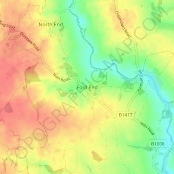
Name: Ford End topographic map, elevation, terrain.
Location: Ford End, Chelmsford, Essex, England, CM3 1LL, United Kingdom (51.80702 0.40939 51.84702 0.44939)
Average elevation: 213 ft
Minimum elevation: 112 ft
Maximum elevation: 295 ft
Other topographic maps
Click on a map to view its topography, its elevation and its terrain.
Hanningfield Reservoir
United Kingdom > England > Essex > Chelmsford > South Hanningfield
Average elevation: 184 ft
Little Waltham
United Kingdom > England > Essex > Chelmsford > Little Waltham
Average elevation: 174 ft
South Hanningfield
United Kingdom > England > Essex > Chelmsford > Ramsden Heath
Average elevation: 187 ft