
Ivel topographic map
Click on the map to display elevation.
About this map
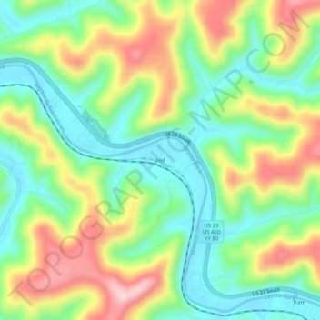
Name: Ivel topographic map, elevation, terrain.
Location: Ivel, Floyd County, Kentucky, 41603, United States (37.57121 -82.68821 37.61121 -82.64821)
Average elevation: 925 ft
Minimum elevation: 617 ft
Maximum elevation: 1,404 ft
Floyd County trails, hiking, mountain biking, running and outdoor activities
Other topographic maps
Click on a map to view its topography, its elevation and its terrain.