Geolocate

Elgin topographic map

Click on the map to display elevation.

About this map

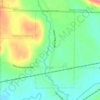
Name: Elgin topographic map, elevation, terrain.

Location: Elgin, Erie County, Pennsylvania, 16413, United States (41.89747 -79.76172 41.91816 -79.73475)

Average elevation: 1,417 ft

Minimum elevation: 1,322 ft

Maximum elevation: 1,585 ft

Erie County trails, hiking, mountain biking, running and outdoor activities

Other topographic maps

Click on a map to view its topography, its elevation and its terrain.

Little Hope

United States > Pennsylvania > Erie County

Average elevation: 1,421 ft

Erie

United States > Pennsylvania > Erie County > Erie

Average elevation: 833 ft

Jackson

United States > Pennsylvania > Erie County > Jackson

Average elevation: 1,306 ft

Belleview Heights

United States > Pennsylvania > Erie County

Average elevation: 1,171 ft

Gear up for your next adventure:

😴Insulated Sleeping Pads - Compact and warm pads for high-elevation camping
🪶Compact Camp Shovel - Folding shovel for campsite tasks
🧦Merino Wool Socks - Moisture-wicking, blister-preventing socks for long treks
🔥Camping Stove - Portable stove for camping and backcountry cooking
🧭GPS Watch Accessories - Bands and chargers for GPS watches

As an Amazon Associate, this site earns from qualifying purchases at no extra cost to you.