
Hart's Location topographic map
Click on the map to display elevation.
About this map
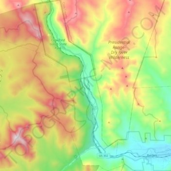
Name: Hart's Location topographic map, elevation, terrain.
Average elevation: 2,316 ft
Minimum elevation: 627 ft
Maximum elevation: 4,619 ft
Carroll County trails, hiking, mountain biking, running and outdoor activities
Other topographic maps
Click on a map to view its topography, its elevation and its terrain.
Winnipesaukee
United States > New Hampshire > Carroll County > Moultonborough
Average elevation: 528 ft
Little Bear Island
United States > New Hampshire > Carroll County > Tuftonboro
Average elevation: 525 ft
Black Cat Island
United States > New Hampshire > Carroll County > Moultonborough
Average elevation: 512 ft
Nineacre Island
United States > New Hampshire > Carroll County > Moultonborough
Average elevation: 518 ft
Whortleberry Island
United States > New Hampshire > Carroll County > Tuftonboro > Chase Point
Average elevation: 512 ft
Cow Island
United States > New Hampshire > Carroll County > Tuftonboro > Fox Point
Average elevation: 531 ft
Castle in the Clouds
United States > New Hampshire > Carroll County > Moultonborough
Average elevation: 1,191 ft
Mirror Lake
United States > New Hampshire > Carroll County > Tuftonboro > Mirror Lake
Average elevation: 554 ft
Winnipesaukee
United States > New Hampshire > Carroll County > Moultonborough
Average elevation: 528 ft
Whortleberry Island
United States > New Hampshire > Carroll County > Tuftonboro > Chase Point
Average elevation: 512 ft
Mount Roberts
United States > New Hampshire > Carroll County > Moultonborough
Average elevation: 2,005 ft
Albany
United States > New Hampshire > Carroll County > Albany
According to the United States Census Bureau, the town has a total area of 75.8 square miles (196.2 km2), of which 75.1 square miles (194.6 km2) are land and 0.58 square miles (1.5 km2) are water, comprising 0.79% of the town. It is drained by the Swift River in the north and the Chocorua River in the south.…
Average elevation: 906 ft