Geolocate

Elk River topographic map

Click on the map to display elevation.

About this map

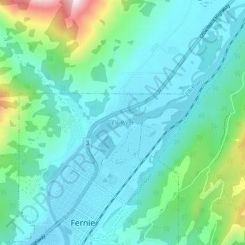
Name: Elk River topographic map, elevation, terrain.

Location: Elk River, Fernie, Regional District of East Kootenay, British Columbia, Canada (49.50000 -115.07339 49.54589 -115.01203)

Average elevation: 3,720 ft

Minimum elevation: 3,258 ft

Maximum elevation: 5,846 ft

Other topographic maps

Click on a map to view its topography, its elevation and its terrain.

Gear up for your next adventure:

🚁Photography Drones - Capture stunning aerial views of landforms and topography
🍳Camping Cook Set - Complete cookware for outdoor meals
🪶LED Camping Lantern - Bright lantern for camp lighting
🧤Tactile Hiking Gloves - Keep hands warm while operating GPS and smartphone screens
📦Dry Bags Set - Waterproof storage for electronics and clothes

As an Amazon Associate, this site earns from qualifying purchases at no extra cost to you.