
Thank you for supporting this site ❤️
Make a donation
Make a donation
Gear up for your next adventure:
As an Amazon Associate, this site earns from qualifying purchases at no extra cost to you.
Fernie topographic map
Click on the map to display elevation.
Thank you for supporting this site ❤️
Make a donation
Make a donation
Gear up for your next adventure:
As an Amazon Associate, this site earns from qualifying purchases at no extra cost to you.
About this map
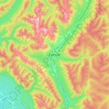
Name: Fernie topographic map, elevation, terrain.
Average elevation: 5,089 ft
Minimum elevation: 2,605 ft
Maximum elevation: 9,301 ft
Thank you for supporting this site ❤️
Make a donation
Make a donation
Gear up for your next adventure:
As an Amazon Associate, this site earns from qualifying purchases at no extra cost to you.
Other topographic maps
Click on a map to view its topography, its elevation and its terrain.
Maiden Lake
Canada > British Columbia > Regional District of East Kootenay > Fernie
Average elevation: 3,428 ft
Elk River
Canada > British Columbia > Regional District of East Kootenay > Fernie
Average elevation: 3,720 ft