
Cap-Chat topographic map
Click on the map to display elevation.
About this map
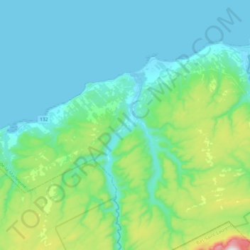
Name: Cap-Chat topographic map, elevation, terrain.
Average elevation: 545 ft
Minimum elevation: -13 ft
Maximum elevation: 3,356 ft
Other topographic maps
Click on a map to view its topography, its elevation and its terrain.
Lac Cameron
Canada > Quebec > La Haute-Gaspésie > Saint-Maxime-du-Mont-Louis
Average elevation: 1,762 ft
Madeleine-Centre
Canada > Quebec > La Haute-Gaspésie > Sainte-Madeleine-de-la-Rivière-Madeleine
Average elevation: 236 ft
Rivière-la-Madeleine
Canada > Quebec > La Haute-Gaspésie > Sainte-Madeleine-de-la-Rivière-Madeleine
Average elevation: 151 ft
Notre Dame Mountains
Canada > Quebec > La Haute-Gaspésie > Mont-Albert
The Chic-Choc Mountains are one of the primary subranges of the Notre Dame Mountains. They are located in the northeastern part of the Gaspé Peninsula and are home to the tallest mountain in the range, Mont Jacques-Cartier, with an elevation of 1,268 m (4,160 ft). The other major subsection of the Notre Dame…
Average elevation: 3,701 ft