Geolocate

Characato topographic map

Click on the map to display elevation.

Characato

Characato is a district of Arequipa Province, Peru. It is located to the southeast of Arequipa, at an average elevation of 3,505 meters above the sea level. As of the year 2022, it had a population of 17,706.

Wikipedia (CC-BY-SA 3.0)

About this map

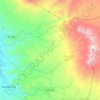
Name: Characato topographic map, elevation, terrain.

Location: Characato, Province of Arequipa, Arequipa, Peru (-16.49520 -71.51616 -16.40309 -71.23930)

Average elevation: 11,499 ft

Minimum elevation: 7,844 ft

Maximum elevation: 18,537 ft

Other topographic maps

Click on a map to view its topography, its elevation and its terrain.

S

Peru > Arequipa > Cerro Colorado

Average elevation: 8,901 ft

Marcella

Peru > Arequipa > Jaquí

Average elevation: 4,406 ft

Colca Canyon

Peru > Arequipa > Choco > Soro

Colca-Arequipa 14 plains of Majes, it is known as the Majes River, and then is known as the Camana before reaching the Pacific Ocean at the town of that name. The Majes River was believed by the Incas to flow directly into the Milky Way. For this reason, they often put sacrifices and gifts to the gods in the…

Average elevation: 10,397 ft

Lacra

Peru > Arequipa > Callalli > Chichas

Average elevation: 14,078 ft

Laura

Peru > Arequipa > San Antonio de Chuca

Average elevation: 14,793 ft

Province of Caylloma

Peru > Arequipa

Average elevation: 12,126 ft

El Misti

Peru > Arequipa > Chiguata

Average elevation: 17,277 ft

Villa Miguel Grau

Peru > Arequipa > Paucarpata > Banos de Jesus

Average elevation: 8,560 ft

Nevado Coropuna

Peru > Arequipa > Salamanca

Coropuna is a dormant compound volcano located in the Andes mountains of southeast-central Peru. The upper reaches of Coropuna consist of several perennially snowbound conical summits, lending it the name Nevado Coropuna in Spanish. The complex extends over an area of 240 square kilometres (93 sq mi) and its…

Average elevation: 19,619 ft

Chachani Volcano

Peru > Arequipa > Yura

The volcano lies in the Andes of southern Peru, 22 kilometres (14 mi) northwest of Arequipa and north of the Arequipa Airport; the city of Arequipa is situated on the foot of Chachani and El Misti volcanoes. The road from Arequipa to Chivay runs along the southeastern foot of Chachani, and a dirt road reaches…

Average elevation: 18,248 ft

Catamarca

Peru > Arequipa > Tisco

Average elevation: 13,875 ft

Laya

Peru > Arequipa > Socabaya > Laya

Average elevation: 7,776 ft

Villa Sevilla

Peru > Arequipa > Jacobo Hunter > Villa Sevilla

Average elevation: 7,490 ft

Mollendo

Peru > Arequipa > Mollendo > Mollendo

Average elevation: 328 ft

Choco

Peru > Arequipa > Choco

Average elevation: 9,406 ft

Apalpampa

Peru > Arequipa > Andaray

Average elevation: 10,003 ft

Pisa

Peru > Arequipa > Callalli

Average elevation: 14,600 ft

Malaga

Peru > Arequipa > Santa Rita de Siguas > Castro

Average elevation: 4,072 ft

Magdalena

Peru > Arequipa > Bella Unión

Average elevation: 5,528 ft

Gear up for your next adventure:

🌧️Backpack Rain Cover - Keep gear dry in wet weather
🪶Trail Camera - Capture wildlife on your hikes
🩳Quick‑Dry Hiking Shorts - Comfortable and quick‑dry shorts for summer hiking
🎒Outdoor Daypacks - Lightweight backpacks designed for carrying maps and essential gear
🎒Gear Packing Cubes - Organize your backpack efficiently

As an Amazon Associate, this site earns from qualifying purchases at no extra cost to you.