Geolocate

Daniel topographic map

Click on the map to display elevation.

About this map

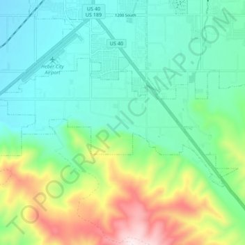
Name: Daniel topographic map, elevation, terrain.

Location: Daniel, Wasatch County, Utah, United States (40.44788 -111.44793 40.48148 -111.36381)

Average elevation: 6,129 ft

Minimum elevation: 5,505 ft

Maximum elevation: 7,756 ft

Wasatch County trails, hiking, mountain biking, running and outdoor activities

Other topographic maps

Click on a map to view its topography, its elevation and its terrain.

Jordanelle

United States > Utah > Wasatch County

Average elevation: 6,447 ft

Heber City

United States > Utah > Wasatch County > Heber > Heber City

Average elevation: 5,771 ft

Soapstone Mountain

United States > Utah > Wasatch County

Average elevation: 8,924 ft

Phosphate Hill

United States > Utah > Wasatch County

Average elevation: 6,309 ft

Silver Lake

United States > Utah > Wasatch County

Average elevation: 9,491 ft

Gear up for your next adventure:

🪶Camping Sleeping Pad - Comfortable sleeping pad for backpacking
💧Water Purification System - Clean water on the trail with reliable purifiers
🍳Camping Cook Set - Complete cookware for outdoor meals
📦Gear Storage Bags - Organize and protect outdoor equipment
🪶LED Camping Lantern - Bright lantern for camp lighting

As an Amazon Associate, this site earns from qualifying purchases at no extra cost to you.