Geolocate

Woodbranch topographic map

Click on the map to display elevation.

About this map

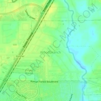
Name: Woodbranch topographic map, elevation, terrain.

Location: Woodbranch, Montgomery County, Texas, United States (30.17292 -95.20104 30.19006 -95.16852)

Average elevation: 102 ft

Minimum elevation: 69 ft

Maximum elevation: 128 ft

Montgomery County trails, hiking, mountain biking, running and outdoor activities

Other topographic maps

Click on a map to view its topography, its elevation and its terrain.

Grangerland

United States > Texas > Montgomery County

Average elevation: 151 ft

Porter

United States > Texas > Montgomery County

Average elevation: 98 ft

Shepard Hill

United States > Texas > Montgomery County

Average elevation: 282 ft

Pinehurst

United States > Texas > Montgomery County

Average elevation: 220 ft

Willis

United States > Texas > Montgomery County > Willis > Willis

Average elevation: 322 ft

Conroe

United States > Texas > Montgomery County > Conroe > Conroe

Average elevation: 197 ft

Security

United States > Texas > Montgomery County

Average elevation: 174 ft

Karen

United States > Texas > Montgomery County

Average elevation: 220 ft

Sorters

United States > Texas > Montgomery County

Average elevation: 98 ft

Mill Creek

United States > Texas > Montgomery County

Average elevation: 184 ft

Pittsville

United States > Texas > Montgomery County > Pittsville

Average elevation: 89 ft

Egypt

United States > Texas > Montgomery County

Average elevation: 207 ft

Gear up for your next adventure:

👓Polarized Sunglasses - Outdoor sunglasses for glare reduction
🧥Men's Rain Shells - Premium waterproof and breathable jackets for mountain weather
🪶Multi‑Purpose Knife - Useful blade for camp and trail
🦶Carbon Trekking Poles - Reduce knee impact on steep descents with ultra-light poles
🪶Trail Camera - Capture wildlife on your hikes

As an Amazon Associate, this site earns from qualifying purchases at no extra cost to you.