Geolocate

Creedmoor topographic map

Click on the map to display elevation.

About this map

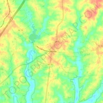
Name: Creedmoor topographic map, elevation, terrain.

Location: Creedmoor, Granville County, North Carolina, United States (36.10083 -78.71870 36.14417 -78.61971)

Average elevation: 331 ft

Minimum elevation: 246 ft

Maximum elevation: 433 ft

Granville County trails, hiking, mountain biking, running and outdoor activities

Other topographic maps

Click on a map to view its topography, its elevation and its terrain.

Grissom

United States > North Carolina > Granville County

Average elevation: 410 ft

Wilton

United States > North Carolina > Granville County

Average elevation: 407 ft

Gear up for your next adventure:

🌡️Portable Weather Meter - Track weather conditions on the trail
🚪Portable Camp Chair - Foldable chair for comfort at camp
📡GPS Antenna Upgrade - Enhance GPS reception in remote terrain
👓Polarized Sunglasses - Outdoor sunglasses for glare reduction
Backpacking Tents - Weight-optimized shelters for multi-day topographic surveys

As an Amazon Associate, this site earns from qualifying purchases at no extra cost to you.