Geolocate

Pine Cliffs topographic map

Click on the map to display elevation.

About this map

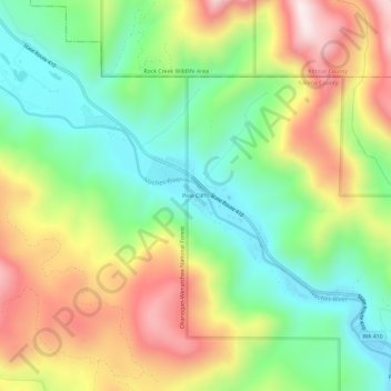
Name: Pine Cliffs topographic map, elevation, terrain.

Location: Pine Cliffs, Yakima County, Washington, United States (46.87913 -121.03240 46.91913 -120.99240)

Average elevation: 2,982 ft

Minimum elevation: 2,149 ft

Maximum elevation: 4,163 ft

Yakima County trails, hiking, mountain biking, running and outdoor activities

Other topographic maps

Click on a map to view its topography, its elevation and its terrain.

Yakima

United States > Washington > Yakima County

Average elevation: 1,237 ft

Selah

United States > Washington > Yakima County

Average elevation: 1,296 ft

Sunnyside

United States > Washington > Yakima County

Average elevation: 741 ft

Naches

United States > Washington > Yakima County

Average elevation: 1,568 ft

Wenas Lake

United States > Washington > Yakima County

Average elevation: 2,070 ft

Nile

United States > Washington > Yakima County > Nile

Average elevation: 2,644 ft

Toppenish

United States > Washington > Yakima County

Average elevation: 761 ft

Yakima

United States > Washington > Yakima County

Average elevation: 1,237 ft

Grandview

United States > Washington > Yakima County

Average elevation: 778 ft

Sunnyside

United States > Washington > Yakima County

Average elevation: 741 ft

Sunnyside

United States > Washington > Yakima County

Average elevation: 741 ft

Yakima

United States > Washington > Yakima County

Average elevation: 1,237 ft

Nile

United States > Washington > Yakima County > Nile

Average elevation: 2,644 ft

Gleed

United States > Washington > Yakima County

Average elevation: 1,391 ft

Nile

United States > Washington > Yakima County > Nile

Average elevation: 2,644 ft

Yakima

United States > Washington > Yakima County

Average elevation: 1,237 ft

Yakima

United States > Washington > Yakima County

Average elevation: 1,237 ft

Tampico

United States > Washington > Yakima County > Tampico

Average elevation: 2,313 ft

Wapato

United States > Washington > Yakima County

Average elevation: 853 ft

Union Gap

United States > Washington > Yakima County

Average elevation: 1,037 ft

Nile

United States > Washington > Yakima County > Nile

Average elevation: 2,644 ft

Selah

United States > Washington > Yakima County

Average elevation: 1,296 ft

Tieton

United States > Washington > Yakima County

Average elevation: 1,949 ft

Nile

United States > Washington > Yakima County > Nile

Average elevation: 2,644 ft

Mabton

United States > Washington > Yakima County

Average elevation: 715 ft

Nile

United States > Washington > Yakima County > Nile

Average elevation: 2,644 ft

Zillah

United States > Washington > Yakima County

Average elevation: 853 ft

Gear up for your next adventure:

🧣Hiking Neck Gaiter - Multi‑use neck protection for outdoor weather
🍳Camping Cook Set - Complete cookware for outdoor meals
🪶Paracord Bracelet - Survival bracelet with built‑in tools
🥾Men's Hiking Boots - Durable, waterproof footwear for rugged terrain and steep inclines
🏫Relief Map Kits - Hands-on tools for teaching landforms and elevation

As an Amazon Associate, this site earns from qualifying purchases at no extra cost to you.