
Sawtooth topographic map
Click on the map to display elevation.
About this map
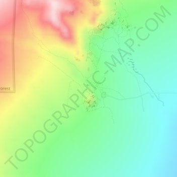
Name: Sawtooth topographic map, elevation, terrain.
Average elevation: 6,053 ft
Minimum elevation: 5,646 ft
Maximum elevation: 6,726 ft
Cassia County trails, hiking, mountain biking, running and outdoor activities
Other topographic maps
Click on a map to view its topography, its elevation and its terrain.
Declo
United States > Idaho > Cassia County
Declo is located at 42°31′10″N 113°37′48″W / 42.51944°N 113.63000°W / 42.51944; -113.63000 (42.519441, -113.629978), at an elevation of 4,219 feet (1,286 m) above sea level. According to the United States Census Bureau, the city has a total area of 0.28 square miles (0.73 km2), all of it land.
Average elevation: 4,213 ft