
Para topographic map
Interactive map
Click on the map to display elevation.
About this map
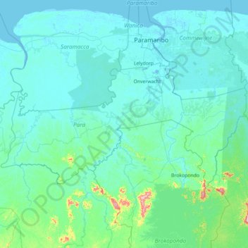
Name: Para topographic map, elevation, terrain.
Location: Para, Suriname (4.98450 -56.02786 5.70137 -54.62486)
Average elevation: 95 ft
Minimum elevation: -13 ft
Maximum elevation: 1,686 ft
Other topographic maps
Click on a map to view its topography, its elevation and its terrain.
Anna Marie
Suriname > Saramacca > Tijgerkreek > Anna Marie
Anna Marie, Tijgerkreek, Saramacca, Suriname
Average elevation: 16 ft
Paramaribo
Suriname > Paramaribo > Centrum
Paramaribo, Centrum, Paramaribo, Suriname
Average elevation: 10 ft