
Long Island topographic map
Interactive map
Click on the map to display elevation.
About this map
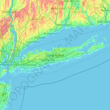
Name: Long Island topographic map, elevation, terrain.
Location: Long Island, New York, United States (40.54190 -74.04197 41.16116 -71.85627)
Average elevation: 138 ft
Minimum elevation: -16 ft
Maximum elevation: 1,634 ft
The land to the south of this moraine to the South Shore is the outwash plain of the last glacier. One part of the outwash plain was known as the Hempstead Plains, and this land contained one of the few natural prairies to exist east of the Appalachian Mountains. The glaciers melted and receded to the north, resulting in the difference between the topography of the North Shore beaches and the South Shore beaches. The North Shore beaches are rocky from the remaining glacial debris, while the South Shore's are crisp, clear, outwash sand. Jayne's Hill, at 401 feet (122 m), within Suffolk County near its border with Nassau County, is the highest hill along either moraine; another well-known summit is Bald Hill in Brookhaven Town, not far from its geographical center at Middle Island. The glaciers also formed Lake Ronkonkoma in Suffolk County and Lake Success in Nassau County, each a deep kettle lake.
Other topographic maps
Click on a map to view its topography, its elevation and its terrain.
Manhattan
United States > New York > New York County > New York
Manhattan, New York County, New York, United States
Average elevation: 52 ft
City of Syracuse
United States > New York > Onondaga County
City of Syracuse, Onondaga County, New York, United States
Average elevation: 564 ft
Adirondack Park
Adirondack Park, New York, United States
Average elevation: 1,217 ft
Fillmore Glen State Park
United States > New York > Cayuga County > Village of Moravia
Fillmore Glen State Park, Village of Moravia, Town of Locke, Cayuga County, New York, United States
Average elevation: 1,365 ft
Buffalo
United States > New York > Erie County
Buffalo, Erie County, New York, United States
Average elevation: 607 ft
City of Ithaca
United States > New York > Tompkins County
City of Ithaca, Tompkins County, New York, United States
Average elevation: 640 ft
Monroe County
Monroe County, New York, United States
Average elevation: 400 ft
City of Binghamton
United States > New York > Broome County
City of Binghamton, Broome County, New York, 13905, United States
Average elevation: 1,053 ft
Upper West Side
United States > New York > New York
Upper West Side, Manhattan Community Board 7, Manhattan, New York County, New York, United States
Average elevation: 75 ft
Town of Huntington
United States > New York > Suffolk County
Town of Huntington, Suffolk County, New York, United States
Average elevation: 98 ft
Lake George
United States > New York > Warren County > Town of Bolton
Lake George, Town of Bolton, Warren County, New York, United States
Average elevation: 810 ft
Town of Marbletown
United States > New York > Ulster County
Town of Marbletown, Ulster County, New York, United States
Average elevation: 413 ft
Putnam County
Putnam County, New York, United States
Average elevation: 554 ft
The Bronx
United States > New York > New York
The Bronx, New York, United States
Average elevation: 75 ft
Orange County
Orange County, New York, United States
Average elevation: 636 ft
Brooklyn
United States > New York > New York
Brooklyn, Kings County, New York, United States
Average elevation: 30 ft
Saratoga Springs
United States > New York > Saratoga County > Saratoga Springs
Saratoga Springs, City of Saratoga Springs, Saratoga County, New York, 12866, United States
Average elevation: 528 ft
Montauk
United States > New York > Suffolk County > Town of East Hampton
Montauk, Town of East Hampton, Suffolk County, New York, 11954, United States
Average elevation: 7 ft
Lester
United States > New York > Broome County
Lester, Town of Windsor, Broome County, New York, United States
Average elevation: 1,581 ft
Town of Catskill
United States > New York > Greene County
Town of Catskill, Greene County, New York, United States
Average elevation: 194 ft
Manhattan Island
United States > New York > New York
Manhattan Island, New York, United States
Average elevation: 56 ft
Dutchess County
Dutchess County, New York, United States
Average elevation: 587 ft
East Hampton
United States > New York > Suffolk County > East Hampton > Village of East Hampton
East Hampton, Village of East Hampton, Suffolk County, New York, 11937, United States
Average elevation: 39 ft
Cortland County
Cortland County, New York, United States
Average elevation: 1,486 ft
Crittenden Road Ball Diamonds
United States > New York > Monroe County > City of Rochester
Crittenden Road Ball Diamonds, Genesee Valley Park, City of Rochester, Monroe County, New York, United States
Average elevation: 528 ft
City of Schenectady
United States > New York > Schenectady County
City of Schenectady, Schenectady County, New York, 12345, United States
Average elevation: 328 ft
Troy
United States > New York > Rensselaer County
Troy, Rensselaer County, New York, 12181, United States
Average elevation: 449 ft
Rensselaer County
Rensselaer County, New York, United States
Average elevation: 784 ft
City of White Plains
United States > New York > Westchester County
City of White Plains, Westchester County, New York, United States
Average elevation: 272 ft
City of Albany
United States > New York > Albany County
City of Albany, Albany County, New York, United States
Average elevation: 223 ft
Village of Westbury
United States > New York > Nassau County
Village of Westbury, Town of North Hempstead, Nassau County, New York, United States
Average elevation: 128 ft
City of Rye
United States > New York > Westchester County
City of Rye, Westchester County, New York, United States
Average elevation: 30 ft
City of Plattsburgh
United States > New York > Clinton County
City of Plattsburgh, Clinton County, New York, United States
Average elevation: 164 ft
Town of Perth
United States > New York > Fulton County
Town of Perth, Fulton County, New York, 12086, United States
Average elevation: 764 ft
Tompkins County
Tompkins County, New York, United States
Average elevation: 1,237 ft
Westchester County
Westchester County, New York, United States
Average elevation: 312 ft
Oneida County
Oneida County, New York, United States
Average elevation: 1,086 ft
City of Yonkers
United States > New York > Westchester County
City of Yonkers, Westchester County, New York, United States
Average elevation: 190 ft
Beacon Hills
United States > New York > Dutchess County > Town of Fishkill
Beacon Hills, Town of Fishkill, Dutchess County, New York, 12527, United States
Average elevation: 518 ft
Town of Butler
United States > New York > Wayne County
Town of Butler, Wayne County, New York, 13154, United States
Average elevation: 436 ft
Town of Clifton Park
United States > New York > Saratoga County
Town of Clifton Park, Saratoga County, New York, United States
Average elevation: 279 ft
Staten Island
United States > New York > New York
Staten Island, Richmond County, New York, United States
Average elevation: 30 ft
Bearsville
United States > New York > Ulster County > Town of Woodstock
Bearsville, Town of Woodstock, Ulster County, New York, 12409, United States
Average elevation: 932 ft
Columbia County
Columbia County, New York, United States
Average elevation: 643 ft
New York County
United States > New York > New York
New York County, New York, United States
Average elevation: 52 ft
Cossayuna
United States > New York > Washington County > Town of Greenwich
Cossayuna, Town of Greenwich, Washington County, New York, 12823, United States
Average elevation: 640 ft