
Effingham topographic map
Click on the map to display elevation.
Effingham
According to the United States Census Bureau, the town of Effingham has a total area of 39.9 square miles (103.4 km2), of which 38.8 square miles (100.4 km2) are land and 1.2 square miles (3.0 km2) are water, comprising 2.87% of the town. Green Mountain, elevation 1,884 feet (574 m), is the highest point in town. Effingham is drained by the Ossipee River and the Ossipee's tributaries, the Pine and South rivers. Province Lake lies partially within the town's borders to the south, and small portions of Ossipee Lake (Broad Bay and Berry Bay) are contained to the north. The community is bounded on the east by the Maine state line, and on the north by the Ossipee River. Effingham lies fully within the Saco River watershed. The Ossipee River subwatershed, partially in Effingham, is home to the largest stratified-drift aquifer in New Hampshire. Much of Effingham's land serves as aquifer recharge areas.
About this map
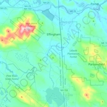
Name: Effingham topographic map, elevation, terrain.
Average elevation: 617 ft
Minimum elevation: 361 ft
Maximum elevation: 1,873 ft
Carroll County trails, hiking, mountain biking, running and outdoor activities
Other topographic maps
Click on a map to view its topography, its elevation and its terrain.
Winnipesaukee
United States > New Hampshire > Carroll County > Moultonborough
Average elevation: 528 ft
Little Bear Island
United States > New Hampshire > Carroll County > Tuftonboro
Average elevation: 525 ft
Black Cat Island
United States > New Hampshire > Carroll County > Moultonborough
Average elevation: 512 ft
Nineacre Island
United States > New Hampshire > Carroll County > Moultonborough
Average elevation: 518 ft
Whortleberry Island
United States > New Hampshire > Carroll County > Tuftonboro > Chase Point
Average elevation: 512 ft
Cow Island
United States > New Hampshire > Carroll County > Tuftonboro > Fox Point
Average elevation: 531 ft
Castle in the Clouds
United States > New Hampshire > Carroll County > Moultonborough
Average elevation: 1,191 ft
Mirror Lake
United States > New Hampshire > Carroll County > Tuftonboro > Mirror Lake
Average elevation: 554 ft
Winnipesaukee
United States > New Hampshire > Carroll County > Moultonborough
Average elevation: 528 ft
Whortleberry Island
United States > New Hampshire > Carroll County > Tuftonboro > Chase Point
Average elevation: 512 ft
Mount Roberts
United States > New Hampshire > Carroll County > Moultonborough
Average elevation: 2,005 ft
Albany
United States > New Hampshire > Carroll County > Albany
According to the United States Census Bureau, the town has a total area of 75.8 square miles (196.2 km2), of which 75.1 square miles (194.6 km2) are land and 0.58 square miles (1.5 km2) are water, comprising 0.79% of the town. It is drained by the Swift River in the north and the Chocorua River in the south.…
Average elevation: 906 ft