
Make a donation
Gear up for your next adventure:
As an Amazon Associate, this site earns from qualifying purchases at no extra cost to you.
Mohokare Local Municipality topographic map
Click on the map to display elevation.
Make a donation
Gear up for your next adventure:
As an Amazon Associate, this site earns from qualifying purchases at no extra cost to you.
About this map
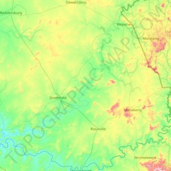
Name: Mohokare Local Municipality topographic map, elevation, terrain.
Average elevation: 4,938 ft
Minimum elevation: 4,131 ft
Maximum elevation: 7,969 ft
Make a donation
Gear up for your next adventure:
As an Amazon Associate, this site earns from qualifying purchases at no extra cost to you.
Other topographic maps
Click on a map to view its topography, its elevation and its terrain.
Zastron
South Africa > Free State > Xhariep District Municipality > Mohokare Local Municipality
Average elevation: 5,640 ft
Reddersburg
South Africa > Free State > Xhariep District Municipality > Kopanong Local Municipality
Average elevation: 4,669 ft
Rouxville
South Africa > Free State > Xhariep District Municipality > Mohokare Local Municipality
Average elevation: 4,980 ft
Smithfield
South Africa > Free State > Xhariep District Municipality > Mohokare Local Municipality
Average elevation: 4,728 ft
Make a donation
Gear up for your next adventure:
As an Amazon Associate, this site earns from qualifying purchases at no extra cost to you.
Tierpoort
South Africa > Free State > Xhariep District Municipality > Kopanong Local Municipality
Average elevation: 4,268 ft
Fauresmith
South Africa > Free State > Xhariep District Municipality > Kopanong Local Municipality
Average elevation: 4,629 ft
Van Stadensrus
South Africa > Free State > Xhariep District Municipality > Naledi Local Municipality
Average elevation: 4,852 ft
Jacobsdal
South Africa > Free State > Xhariep District Municipality > Letsemeng Local Municipality
Average elevation: 3,763 ft
Make a donation
Gear up for your next adventure:
As an Amazon Associate, this site earns from qualifying purchases at no extra cost to you.
Paardeberg
South Africa > Free State > Xhariep District Municipality > Letsemeng Local Municipality
Average elevation: 3,832 ft
Dewetsdorp
South Africa > Free State > Xhariep District Municipality > Naledi Local Municipality
Average elevation: 5,138 ft
Gariep Dam
South Africa > Free State > Xhariep District Municipality > Kopanong Local Municipality
Average elevation: 4,154 ft
Koffiefontein
South Africa > Free State > Xhariep District Municipality > Letsemeng Local Municipality
Average elevation: 3,947 ft
Make a donation
Gear up for your next adventure:
As an Amazon Associate, this site earns from qualifying purchases at no extra cost to you.
Fauresmith
South Africa > Free State > Xhariep District Municipality > Kopanong Local Municipality
Average elevation: 4,629 ft
Paardeberg
South Africa > Free State > Xhariep District Municipality > Letsemeng Local Municipality
Average elevation: 3,832 ft
Springfontein
South Africa > Free State > Xhariep District Municipality > Kopanong Local Municipality
Average elevation: 5,016 ft
Waterkloof
South Africa > Free State > Xhariep District Municipality > Kopanong Local Municipality
Average elevation: 4,406 ft
Make a donation
Gear up for your next adventure:
As an Amazon Associate, this site earns from qualifying purchases at no extra cost to you.
Zastron
South Africa > Free State > Xhariep District Municipality > Mohokare Local Municipality
Average elevation: 5,640 ft