
Make a donation
Gear up for your next adventure:
As an Amazon Associate, this site earns from qualifying purchases at no extra cost to you.
Villarmayor topographic map
Click on the map to display elevation.
Make a donation
Gear up for your next adventure:
As an Amazon Associate, this site earns from qualifying purchases at no extra cost to you.
About this map
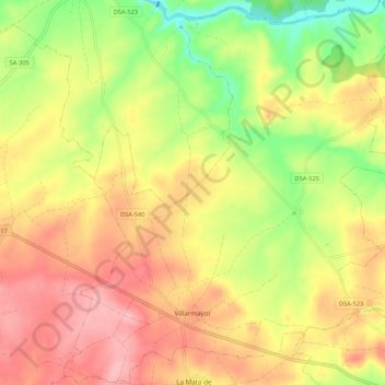
Name: Villarmayor topographic map, elevation, terrain.
Location: Villarmayor, Salamanca, Castile and León, Spain (41.00063 -6.00698 41.08117 -5.91247)
Average elevation: 2,638 ft
Minimum elevation: 2,408 ft
Maximum elevation: 2,825 ft
Make a donation
Gear up for your next adventure:
As an Amazon Associate, this site earns from qualifying purchases at no extra cost to you.
Other topographic maps
Click on a map to view its topography, its elevation and its terrain.
Make a donation
Gear up for your next adventure:
As an Amazon Associate, this site earns from qualifying purchases at no extra cost to you.
Presa Vieja de Las Navas del Marques
Spain > Castile and León > Peguerinos
Average elevation: 4,908 ft
Make a donation
Gear up for your next adventure:
As an Amazon Associate, this site earns from qualifying purchases at no extra cost to you.