
Almagreira topographic map
Interactive map
Click on the map to display elevation.
About this map
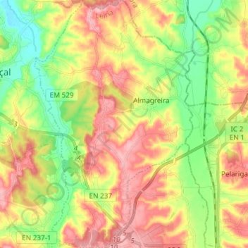
Name: Almagreira topographic map, elevation, terrain.
Location: Almagreira, Pombal, Leiria, 3105-005, Portugal (39.93687 -8.71908 40.03009 -8.64012)
Average elevation: 220 ft
Minimum elevation: 7 ft
Maximum elevation: 446 ft
Other topographic maps
Click on a map to view its topography, its elevation and its terrain.
Chão do Ulmeiro
Portugal > Leiria > Pombal > Vila Cã
Chão do Ulmeiro, Vila Cã, Pombal, Leiria, Portugal
Average elevation: 879 ft
Vale do Feto
Portugal > Leiria > Pombal > Carnide
Vale do Feto, Carnide, Pombal, Leiria, 3105-253, Portugal
Average elevation: 492 ft
Penedos
Portugal > Leiria > Pombal > Almagreira
Penedos, Almagreira, Pombal, Leiria, 3105-005, Portugal
Average elevation: 240 ft
Vale Pomares
Vale Pomares, Santiago e São Simão de Litém e Albergaria dos Doze, Pombal, Leiria, Portugal
Average elevation: 807 ft
Carramanha
Portugal > Leiria > Pombal > Redinha
Carramanha, Redinha, Pombal, Leiria, 3105, Portugal
Average elevation: 213 ft
Praia do Osso da Baleia
Portugal > Leiria > Pombal > Carriço
Praia do Osso da Baleia, Carriço, Pombal, Leiria, Portugal
Average elevation: 33 ft