
Sauk Rapids topographic map
Interactive map
Click on the map to display elevation.
About this map
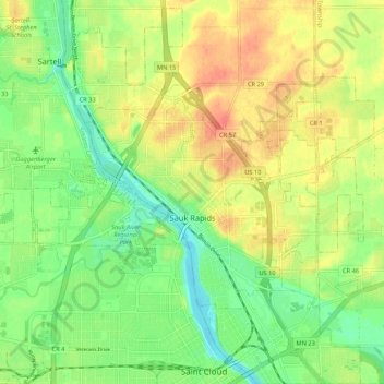
Name: Sauk Rapids topographic map, elevation, terrain.
Location: Sauk Rapids, Benton County, Minnesota, 56379, United States (45.57377 -94.19687 45.61869 -94.09063)
Average elevation: 1,060 ft
Minimum elevation: 981 ft
Maximum elevation: 1,145 ft
Other topographic maps
Click on a map to view its topography, its elevation and its terrain.
Foley
United States > Minnesota > Benton County
Foley, Benton County, Minnesota, 56329, United States
Average elevation: 1,142 ft
Gilman
United States > Minnesota > Benton County
Gilman, Benton County, Minnesota, United States
Average elevation: 1,194 ft
Oak Park
United States > Minnesota > Benton County
Oak Park, Maywood Township, Benton County, Minnesota, 56357, United States
Average elevation: 1,122 ft
Rice
United States > Minnesota > Benton County
Rice, Benton County, Minnesota, United States
Average elevation: 1,066 ft
Watab
United States > Minnesota > Benton County
Watab, Benton County, Minnesota, United States
Average elevation: 1,053 ft