Watab topographic map
Interactive map
Click on the map to display elevation.
About this map
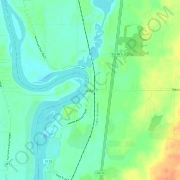
Name: Watab topographic map, elevation, terrain.
Location: Watab, Benton County, Minnesota, United States (45.65635 -94.20110 45.69635 -94.16110)
Average elevation: 1,053 ft
Minimum elevation: 1,007 ft
Maximum elevation: 1,142 ft
Other topographic maps
Click on a map to view its topography, its elevation and its terrain.
Sauk Rapids
United States > Minnesota > Benton County
Sauk Rapids, Benton County, Minnesota, 56379, United States
Average elevation: 1,060 ft
Foley
United States > Minnesota > Benton County
Foley, Benton County, Minnesota, 56329, United States
Average elevation: 1,142 ft
Gilman
United States > Minnesota > Benton County
Gilman, Benton County, Minnesota, United States
Average elevation: 1,194 ft
Oak Park
United States > Minnesota > Benton County
Oak Park, Maywood Township, Benton County, Minnesota, 56357, United States
Average elevation: 1,122 ft
Rice
United States > Minnesota > Benton County
Rice, Benton County, Minnesota, United States
Average elevation: 1,066 ft