
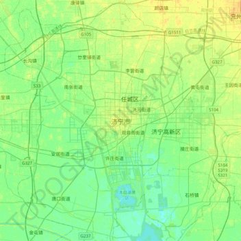
济宁市 topographic map
Interactive map
Click on the map to display elevation.
About this map
Name: 济宁市 topographic map, elevation, terrain.
Location: 济宁市, 任城区, 济宁市, 山东省, 272000, 中国 (35.25250 116.42493 35.57250 116.74493)
Average elevation: 128 ft
Minimum elevation: 102 ft
Maximum elevation: 167 ft
济宁市位于山东省西南部,地处黄淮海平原与鲁中南山丘区交接地带,东部多山,丘陵连绵。京沪铁路以东海拔在50~100米以上,比较有名的山有曲阜尼山(海拔344米),邹城峄山(海拔545米),凤凰山(海拔648.4米,全市最高),泗水尧山(海拔582米)。南四湖以东—东部山麓为泰沂山前冲积平原,自西向东倾斜,地面海拔30~50米,地面起伏较大。南四湖以西为较平坦的黄泛平原,自西向东倾斜,地面海拔39~34米,起伏较小。中部有南四湖贯穿南北。湖北为泰沂山前冲积扇下缘,自东北向西南倾斜,地面海拔60~35米。
Other topographic maps
Click on a map to view its topography, its elevation and its terrain.