
Make a donation
Gear up for your next adventure:
As an Amazon Associate, this site earns from qualifying purchases at no extra cost to you.
番禺区 topographic map
Click on the map to display elevation.
Make a donation
Gear up for your next adventure:
As an Amazon Associate, this site earns from qualifying purchases at no extra cost to you.
番禺区
番禺以东面临狮子洋水道西面与佛山市南海区、顺德区毗邻,南与南沙区一衣带水;北部为海拔50米以下低丘,与广州市荔湾区芳村、海珠区、黄埔区南部一江之隔。
Make a donation
Gear up for your next adventure:
As an Amazon Associate, this site earns from qualifying purchases at no extra cost to you.
About this map
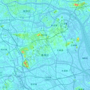
Name: 番禺区 topographic map, elevation, terrain.
Location: 番禺区, 广州市, 广东省, 511400, 中国 (22.86043 113.24397 23.08281 113.57000)
Average elevation: 20 ft
Minimum elevation: -43 ft
Maximum elevation: 600 ft
Make a donation
Gear up for your next adventure:
As an Amazon Associate, this site earns from qualifying purchases at no extra cost to you.
Other topographic maps
Click on a map to view its topography, its elevation and its terrain.
Make a donation
Gear up for your next adventure:
As an Amazon Associate, this site earns from qualifying purchases at no extra cost to you.
Make a donation
Gear up for your next adventure:
As an Amazon Associate, this site earns from qualifying purchases at no extra cost to you.
Make a donation
Gear up for your next adventure:
As an Amazon Associate, this site earns from qualifying purchases at no extra cost to you.
Make a donation
Gear up for your next adventure:
As an Amazon Associate, this site earns from qualifying purchases at no extra cost to you.
Make a donation
Gear up for your next adventure:
As an Amazon Associate, this site earns from qualifying purchases at no extra cost to you.
Make a donation
Gear up for your next adventure:
As an Amazon Associate, this site earns from qualifying purchases at no extra cost to you.
Make a donation
Gear up for your next adventure:
As an Amazon Associate, this site earns from qualifying purchases at no extra cost to you.
Make a donation
Gear up for your next adventure:
As an Amazon Associate, this site earns from qualifying purchases at no extra cost to you.
Make a donation
Gear up for your next adventure:
As an Amazon Associate, this site earns from qualifying purchases at no extra cost to you.
Make a donation
Gear up for your next adventure:
As an Amazon Associate, this site earns from qualifying purchases at no extra cost to you.
Make a donation
Gear up for your next adventure:
As an Amazon Associate, this site earns from qualifying purchases at no extra cost to you.
河源市
河源市地势以山地丘陵为主,东北略高、西南部较低,山岭与盆地相间。东江、新丰江及其支流对其地形分布具有重要影响,在山间和东江沿岸,分布着冲积小平原和宽广的谷地,适于耕作。河源市水资源丰富。贯穿全境的东江,是珠江流域在粤东的最大支流,市内87%面积属东江流域,长约254公里,占东江的总长度超过45%。该段东江水质的质素,2007年,东江河源段六个断面水质良好,所监测的24项指标均符合国家《地表水环境质量标准》(GB3838—2002)Ⅱ类标准,对东江流域沿岸和下游的用水安全有密切关系。而华南地区最大的水库——新丰江水库(又称万绿湖)在其境内,素有“粤东宝库”之称。万绿湖水质一直保持在国家地表水Ⅰ类标准,是为河源市区居民…
Average elevation: 581 ft
Make a donation
Gear up for your next adventure:
As an Amazon Associate, this site earns from qualifying purchases at no extra cost to you.
Make a donation
Gear up for your next adventure:
As an Amazon Associate, this site earns from qualifying purchases at no extra cost to you.
Make a donation
Gear up for your next adventure:
As an Amazon Associate, this site earns from qualifying purchases at no extra cost to you.
Make a donation
Gear up for your next adventure:
As an Amazon Associate, this site earns from qualifying purchases at no extra cost to you.
Make a donation
Gear up for your next adventure:
As an Amazon Associate, this site earns from qualifying purchases at no extra cost to you.
Make a donation
Gear up for your next adventure:
As an Amazon Associate, this site earns from qualifying purchases at no extra cost to you.
Make a donation
Gear up for your next adventure:
As an Amazon Associate, this site earns from qualifying purchases at no extra cost to you.
Make a donation
Gear up for your next adventure:
As an Amazon Associate, this site earns from qualifying purchases at no extra cost to you.
Make a donation
Gear up for your next adventure:
As an Amazon Associate, this site earns from qualifying purchases at no extra cost to you.
Make a donation
Gear up for your next adventure:
As an Amazon Associate, this site earns from qualifying purchases at no extra cost to you.
端州区
端州区位于广东省中部偏西,西江中下游北岸,属于珠江三角洲经济区范围,是肇庆市政治、经济、文化中心。南临西江,北靠北岭山,东邻鼎湖山,西与高要区小湘镇接壤。处于东经112°23′—34′,北纬23°2′—11′之间,西江贯穿其中,区内本有大量小型湖塘分布城区,随着近年城市发展和“城市往东移”、两个新区的建设,大部分池塘已被覆盖。端州区因山、湖、江三者而形成了呈狭长型的市区,区内北部为北岭山,为南岭的一部份,西南部有小型丘陵,以象山最为人所知,东北部有石山岩群,中部有大面积湖塘。独特的地形地貌形成石林、溶洞、孤峰等地貌,如市区的七星岩等。
Average elevation: 325 ft
Make a donation
Gear up for your next adventure:
As an Amazon Associate, this site earns from qualifying purchases at no extra cost to you.
Make a donation
Gear up for your next adventure:
As an Amazon Associate, this site earns from qualifying purchases at no extra cost to you.
Make a donation
Gear up for your next adventure:
As an Amazon Associate, this site earns from qualifying purchases at no extra cost to you.
Make a donation
Gear up for your next adventure:
As an Amazon Associate, this site earns from qualifying purchases at no extra cost to you.