
Make a donation
Gear up for your next adventure:
As an Amazon Associate, this site earns from qualifying purchases at no extra cost to you.
Cammack Village topographic map
Click on the map to display elevation.
Make a donation
Gear up for your next adventure:
As an Amazon Associate, this site earns from qualifying purchases at no extra cost to you.
About this map
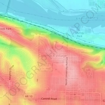
Name: Cammack Village topographic map, elevation, terrain.
Location: Cammack Village, Pulaski County, Arkansas, United States (34.77562 -92.34923 34.78509 -92.34001)
Average elevation: 443 ft
Minimum elevation: 230 ft
Maximum elevation: 633 ft
Pulaski County trails, hiking, mountain biking, running and outdoor activities
Make a donation
Gear up for your next adventure:
As an Amazon Associate, this site earns from qualifying purchases at no extra cost to you.
Other topographic maps
Click on a map to view its topography, its elevation and its terrain.
Make a donation
Gear up for your next adventure:
As an Amazon Associate, this site earns from qualifying purchases at no extra cost to you.
Overlook Park
United States > Arkansas > Pulaski County > Little Rock > Overlook Park
Average elevation: 400 ft
Merrivale
United States > Arkansas > Pulaski County > Little Rock > Merrivale
Average elevation: 299 ft
Two Rivers Park
United States > Arkansas > Pulaski County > Little Rock > Overlook Park
Average elevation: 364 ft
Make a donation
Gear up for your next adventure:
As an Amazon Associate, this site earns from qualifying purchases at no extra cost to you.