Geolocate

Landmark topographic map

Click on the map to display elevation.

About this map

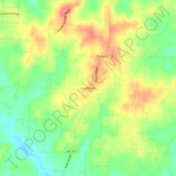
Name: Landmark topographic map, elevation, terrain.

Location: Landmark, Pulaski County, Arkansas, United States (34.59120 -92.33960 34.63120 -92.29960)

Average elevation: 358 ft

Minimum elevation: 249 ft

Maximum elevation: 466 ft

Pulaski County trails, hiking, mountain biking, running and outdoor activities

Other topographic maps

Click on a map to view its topography, its elevation and its terrain.

Alexander

United States > Arkansas > Pulaski County

Average elevation: 377 ft

Wrightsville

United States > Arkansas > Pulaski County

Average elevation: 240 ft

Cammack Village

United States > Arkansas > Pulaski County

Average elevation: 443 ft

Gear up for your next adventure:

🎁Geography Themed Gifts - Unique gift ideas for map lovers and geography enthusiasts
🛰️Handheld GPS Units - Professional satellite navigators for precise backcountry mapping
🛠️Backpacking Tool Kit - Essential toolkit for outdoor repairs
🌐World Map Poster - Decorative world maps with topographic info
📶Vehicle Signal Boosters - Improve reception in rural areas while driving to trailheads

As an Amazon Associate, this site earns from qualifying purchases at no extra cost to you.