
Make a donation
Gear up for your next adventure:
As an Amazon Associate, this site earns from qualifying purchases at no extra cost to you.
Winklsaß topographic map
Click on the map to display elevation.
Make a donation
Gear up for your next adventure:
As an Amazon Associate, this site earns from qualifying purchases at no extra cost to you.
About this map
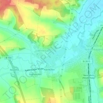
Name: Winklsaß topographic map, elevation, terrain.
Average elevation: 1,368 ft
Minimum elevation: 1,283 ft
Maximum elevation: 1,545 ft
Make a donation
Gear up for your next adventure:
As an Amazon Associate, this site earns from qualifying purchases at no extra cost to you.
Other topographic maps
Click on a map to view its topography, its elevation and its terrain.
Vilsbiburg
Deutschland > Bayern > Landkreis Landshut
Das Pfarrdorf Frauensattling liegt zwischen dem Binatal und dem Vilstal auf einem Höhenrücken auf 490 m Seehöhe. Zum Vilsbiburger Gemeindeteil Frauensattling zählen heute neben Einzelgehöften: Frauensattling, Frauensattling-Grub, Niedersattling, Hörasdorf, Solling. Frauensattling kam durch die…
Average elevation: 1,552 ft
Postau
Deutschland > Bayern > Landkreis Landshut
Armannsberg | Einaich | Grießenbach | Hagmühle | Hahnreuth | Hofberg | Höhenberg | Hopfenspirg | Irlsbrunn | Kirchthann | Moosthann | Oberköllnbach | Postau | Roglkreuth | Stegmühle | Stockau | Trauseneck | Unholzing | Unterköllnbach | Wasenstatt
Average elevation: 1,365 ft
Make a donation
Gear up for your next adventure:
As an Amazon Associate, this site earns from qualifying purchases at no extra cost to you.
Make a donation
Gear up for your next adventure:
As an Amazon Associate, this site earns from qualifying purchases at no extra cost to you.
Oberotterbach
Deutschland > Bayern > Landkreis Landshut > Rottenburg a. d. Laaber
Average elevation: 1,532 ft
Make a donation
Gear up for your next adventure:
As an Amazon Associate, this site earns from qualifying purchases at no extra cost to you.
Adlkofen
Deutschland > Bayern > Landkreis Landshut
Die nebenstehende Graphik mit Einwohnerzahlen von 2003 bis 2012 zeigt, dass der bisherige Höhepunkt zwischen 2004 und 2008 erreicht wurde mit einer leicht sinkenden Tendenz in den Folgejahren. Die Graphik zur Bevölkerungsentwicklung der Jahre 1972 bis 2017 zeigt, dass im Zuge der Ausweisung neuer Wohngebiete…
Average elevation: 1,526 ft
Make a donation
Gear up for your next adventure:
As an Amazon Associate, this site earns from qualifying purchases at no extra cost to you.
Make a donation
Gear up for your next adventure:
As an Amazon Associate, this site earns from qualifying purchases at no extra cost to you.
Geisenhausen
Deutschland > Bayern > Landkreis Landshut
Adermühle | Aign | Aiteröd | Albanstetten | Allmannsberg | Armannsberg | Asang | Asbach | Aukam | Bach | Bettenbach | Birken | Buch | Diemannskirchen | Eiselsdorf | Feichten | Feldkirchen | Feldmühle | Feuerberg | Fimbach | Floiten | Gallersgrub | Gammelsreut | Geisenhausen | Gerzenberg | Gerzer | Giglberg…
Average elevation: 1,572 ft
Make a donation
Gear up for your next adventure:
As an Amazon Associate, this site earns from qualifying purchases at no extra cost to you.
Wörth an der Isar
Deutschland > Bayern > Landkreis Landshut > Wörth a.d.Isar
In Folge einer entsprechenden Bewertung ihrer Wirtschaftskraft wurden der Gemeinde Wörth in den Jahren 2015 bis 2018 vom Freistaat Bayern keine Schlüsselzuweisungen zugeteilt. Im Jahr 2019 erfolgte schließlich eine Zahlung in Höhe von 139.392 Euro. Für das Jahr 2020 gab es dann erneut keine Zuteilung.
Average elevation: 1,257 ft
Make a donation
Gear up for your next adventure:
As an Amazon Associate, this site earns from qualifying purchases at no extra cost to you.
Kreuzthann
Deutschland > Bayern > Landkreis Landshut > Rottenburg a. d. Laaber > Schaltdorf
Average elevation: 1,476 ft
Make a donation
Gear up for your next adventure:
As an Amazon Associate, this site earns from qualifying purchases at no extra cost to you.
Make a donation
Gear up for your next adventure:
As an Amazon Associate, this site earns from qualifying purchases at no extra cost to you.
Make a donation
Gear up for your next adventure:
As an Amazon Associate, this site earns from qualifying purchases at no extra cost to you.
Preisenberg
Deutschland > Bayern > Landkreis Landshut
Allkofen | Allmannsdorf | Altenbach | Berndorf | Dettenkofen | Eck an der Straß | Eichet | Eierkam | Gammel | Götzdorf | Grammelkam | Grillberg | Hachelstuhl | Hausberg | Herbersdorf | Hillersbach | Höhenberg | Hohenegglkofen | Kammer | Kumberg | Kumhausen | Mantelkam | Narrenstetten | Niederkam |…
Average elevation: 1,522 ft
Make a donation
Gear up for your next adventure:
As an Amazon Associate, this site earns from qualifying purchases at no extra cost to you.
Wörth a.d. Isar
Deutschland > Bayern > Landkreis Landshut
In Folge einer entsprechenden Bewertung ihrer Wirtschaftskraft wurden der Gemeinde Wörth in den Jahren 2015 bis 2018 vom Freistaat Bayern keine Schlüsselzuweisungen zugeteilt. Im Jahr 2019 erfolgte schließlich eine Zahlung in Höhe von 139.392 Euro. Für das Jahr 2020 gab es dann erneut keine Zuteilung.
Average elevation: 1,234 ft
Make a donation
Gear up for your next adventure:
As an Amazon Associate, this site earns from qualifying purchases at no extra cost to you.
84137
Deutschland > Bayern > Landkreis Landshut > Vilsbiburg > Gaindorf > Berg
Average elevation: 1,493 ft
Make a donation
Gear up for your next adventure:
As an Amazon Associate, this site earns from qualifying purchases at no extra cost to you.
Moosthann
Deutschland > Bayern > Landkreis Landshut
Armannsberg | Einaich | Grießenbach | Hagmühle | Hahnreuth | Hofberg | Höhenberg | Hopfenspirg | Irlsbrunn | Kirchthann | Moosthann | Oberköllnbach | Postau | Roglkreuth | Stegmühle | Stockau | Trauseneck | Unholzing | Unterköllnbach | Wasenstatt
Average elevation: 1,453 ft
Großaibacherforst
Deutschland > Bayern > Landkreis Landshut > Buch am Erlbach
Average elevation: 1,594 ft
Make a donation
Gear up for your next adventure:
As an Amazon Associate, this site earns from qualifying purchases at no extra cost to you.
Pattendorf
Deutschland > Bayern > Landkreis Landshut > Rottenburg a. d. Laaber
Average elevation: 1,450 ft
Make a donation
Gear up for your next adventure:
As an Amazon Associate, this site earns from qualifying purchases at no extra cost to you.
Niederaichbach
Deutschland > Bayern > Landkreis Landshut
Bergham | Bergsdorf | Egl | Froschgrub | Gadham | Gaishof | Goldern | Grafenöd | Grub | Haag | Haid | Höhenberg | Hüttenkofen | Hutzenthal | Impenbach | Klang | Kollersöd | Lehen | Niederaichbach | Oberaichbach | Oberholz | Oberskirchen | Paring | Reichersdorf | Ruhmannsdorf | Schlegelberg | Taschenmais |…
Average elevation: 1,398 ft
Make a donation
Gear up for your next adventure:
As an Amazon Associate, this site earns from qualifying purchases at no extra cost to you.
Inkofen
Deutschland > Bayern > Landkreis Landshut > Rottenburg a. d. Laaber
Average elevation: 1,460 ft
Kumhausen
Deutschland > Bayern > Landkreis Landshut
Auf dem Gebiet der Gemeinde Kumhausen wurde im Juni 2015 mit der Errichtung einer Windkraftanlage begonnen. Sie hat eine Nabenhöhe von 137 Metern (Rotordurchmesser 126 Meter) und soll Elektrizität an die Stadtwerke Landshut liefern. Es handelt sich um ein Gemeinschaftsprojekt der Stadt Landshut und dem…
Average elevation: 1,519 ft
Make a donation
Gear up for your next adventure:
As an Amazon Associate, this site earns from qualifying purchases at no extra cost to you.
Make a donation
Gear up for your next adventure:
As an Amazon Associate, this site earns from qualifying purchases at no extra cost to you.
Grammelsbrunn
Deutschland > Bayern > Landkreis Landshut > Kröning > Magersdorf
Average elevation: 1,575 ft
Schmatzhausen
Deutschland > Bayern > Landkreis Landshut
80 n. Chr. siedelten die Römer in Regensburg, was ein Straßennetz voraussetzte, welches die Siedlungen im römischen Reich verband. Eine dieser "Römerstraßen" die Moosburg mit Regensburg verband ist heute noch im Müllerholz bei Osterwind zu sehen. Die Verbindungsstraße verläuft von Altdorf kommend über…
Average elevation: 1,552 ft
Make a donation
Gear up for your next adventure:
As an Amazon Associate, this site earns from qualifying purchases at no extra cost to you.
Make a donation
Gear up for your next adventure:
As an Amazon Associate, this site earns from qualifying purchases at no extra cost to you.
Eching
Deutschland > Bayern > Landkreis Landshut
Der Landshuter Höhenwanderweg führt von Buch am Erlbach aus über Niedererlbach, Berghofen, Kronwinkl, Viecht, Tiefenbach bis nach Landshut. Er ist ausgestattet mit Schautafeln und bietet interessante Abstecher.
Average elevation: 1,453 ft
Ergolding
Deutschland > Bayern > Landkreis Landshut
Ergolding grenzt direkt nördlich an die Regierungshauptstadt Niederbayerns Landshut, mit der es mittlerweile zusammengewachsen ist. Topographisch teilt sich Ergolding in das Isartal (südlich der A 92) und das Tertiärhügelland (nördlich der A 92).
Average elevation: 1,368 ft
Make a donation
Gear up for your next adventure:
As an Amazon Associate, this site earns from qualifying purchases at no extra cost to you.
Make a donation
Gear up for your next adventure:
As an Amazon Associate, this site earns from qualifying purchases at no extra cost to you.
Tiefenbach
Deutschland > Bayern > Landkreis Landshut
Die Gemeinde Tiefenbach grenzt unmittelbar an das Stadtgebiet von Landshut an. Eine bauliche Verflechtung ist aufgrund der Topographie jedoch nicht gegeben. Das Gemeindegebiet wird im Norden von der Isar und der Bundesstraße 11 begrenzt. Im Osten verläuft die B 15 Landshut – Rosenheim nahezu parallel…
Average elevation: 1,486 ft
Make a donation
Gear up for your next adventure:
As an Amazon Associate, this site earns from qualifying purchases at no extra cost to you.
Make a donation
Gear up for your next adventure:
As an Amazon Associate, this site earns from qualifying purchases at no extra cost to you.
Emiching
Deutschland > Bayern > Landkreis Landshut > Haunzenbergersöll > Emiching
Average elevation: 1,588 ft
Dasching
Deutschland > Bayern > Landkreis Landshut > Vilsbiburg > Giersdorf > Dasching
Average elevation: 1,565 ft
Make a donation
Gear up for your next adventure:
As an Amazon Associate, this site earns from qualifying purchases at no extra cost to you.