
Make a donation
Gear up for your next adventure:
As an Amazon Associate, this site earns from qualifying purchases at no extra cost to you.
Hörup topographic map
Click on the map to display elevation.
Make a donation
Gear up for your next adventure:
As an Amazon Associate, this site earns from qualifying purchases at no extra cost to you.
About this map
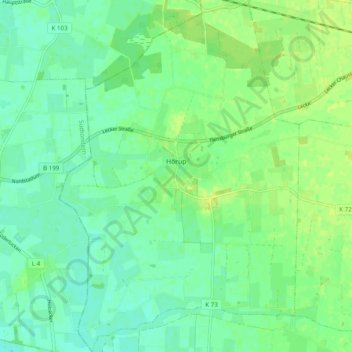
Name: Hörup topographic map, elevation, terrain.
Average elevation: 26 ft
Minimum elevation: 3 ft
Maximum elevation: 52 ft
Make a donation
Gear up for your next adventure:
As an Amazon Associate, this site earns from qualifying purchases at no extra cost to you.
Other topographic maps
Click on a map to view its topography, its elevation and its terrain.
Böklund
Deutschland > Schleswig-Holstein > Schleswig-Flensburg > Böklund > Böklund
Average elevation: 118 ft
Make a donation
Gear up for your next adventure:
As an Amazon Associate, this site earns from qualifying purchases at no extra cost to you.
Brekenrühe
Deutschland > Schleswig-Holstein > Schleswig-Flensburg > Brodersby-Goltoft
Average elevation: 46 ft
Langballigau
Deutschland > Schleswig-Holstein > Schleswig-Flensburg > Langballigholz
Average elevation: 39 ft
Faulück
Deutschland > Schleswig-Holstein > Schleswig-Flensburg > Rabenkirchen-Faulück
Average elevation: 89 ft
Make a donation
Gear up for your next adventure:
As an Amazon Associate, this site earns from qualifying purchases at no extra cost to you.
Make a donation
Gear up for your next adventure:
As an Amazon Associate, this site earns from qualifying purchases at no extra cost to you.
Kopperby-Heide
Deutschland > Schleswig-Holstein > Schleswig-Flensburg > Kappeln > Kopperby
Average elevation: 36 ft
Make a donation
Gear up for your next adventure:
As an Amazon Associate, this site earns from qualifying purchases at no extra cost to you.
Schleswig
Deutschland > Schleswig-Holstein > Schleswig-Flensburg > Schleswig > Schleswig
Average elevation: 79 ft
Make a donation
Gear up for your next adventure:
As an Amazon Associate, this site earns from qualifying purchases at no extra cost to you.
Osterhavetoft
Deutschland > Schleswig-Holstein > Schleswig-Flensburg > Havetoft > Osterhavetoft
Average elevation: 135 ft
Obdrupholz
Deutschland > Schleswig-Holstein > Schleswig-Flensburg > Mittelangeln > Satrup
Average elevation: 121 ft
Rüdeheck
Deutschland > Schleswig-Holstein > Schleswig-Flensburg > Glücksburg (Ostsee)
Average elevation: 72 ft
Koxbüll
Deutschland > Schleswig-Holstein > Schleswig-Flensburg > Süderhackstedt
Average elevation: 59 ft
Make a donation
Gear up for your next adventure:
As an Amazon Associate, this site earns from qualifying purchases at no extra cost to you.
Schwienholm
Deutschland > Schleswig-Holstein > Schleswig-Flensburg > Mittelangeln
Average elevation: 128 ft
Make a donation
Gear up for your next adventure:
As an Amazon Associate, this site earns from qualifying purchases at no extra cost to you.
Karschau
Deutschland > Schleswig-Holstein > Schleswig-Flensburg > Rabenkirchen-Faulück
Average elevation: 43 ft
Süderbrarupholm
Deutschland > Schleswig-Holstein > Schleswig-Flensburg > Süderbrarup
Average elevation: 79 ft
Make a donation
Gear up for your next adventure:
As an Amazon Associate, this site earns from qualifying purchases at no extra cost to you.
Meierwik
Deutschland > Schleswig-Holstein > Schleswig-Flensburg > Glücksburg (Ostsee)
Average elevation: 66 ft
Make a donation
Gear up for your next adventure:
As an Amazon Associate, this site earns from qualifying purchases at no extra cost to you.
Kohlfeld
Deutschland > Schleswig-Holstein > Schleswig-Flensburg > Mittelangeln > Satrup
Average elevation: 118 ft
Make a donation
Gear up for your next adventure:
As an Amazon Associate, this site earns from qualifying purchases at no extra cost to you.
Dollerupholz
Deutschland > Schleswig-Holstein > Schleswig-Flensburg > Westerholz
Average elevation: 49 ft
Munkwolstrup
Deutschland > Schleswig-Holstein > Schleswig-Flensburg > Munkwolstrup
Average elevation: 135 ft
Make a donation
Gear up for your next adventure:
As an Amazon Associate, this site earns from qualifying purchases at no extra cost to you.
Nübel
Deutschland > Schleswig-Holstein > Schleswig-Flensburg > Nübelfeld > Nübel
Average elevation: 125 ft
Make a donation
Gear up for your next adventure:
As an Amazon Associate, this site earns from qualifying purchases at no extra cost to you.
Haurup
Deutschland > Schleswig-Holstein > Schleswig-Flensburg > Handewitt > Haurup
Average elevation: 108 ft
Ellund
Deutschland > Schleswig-Holstein > Schleswig-Flensburg > Handewitt > Ellund
Average elevation: 108 ft
Make a donation
Gear up for your next adventure:
As an Amazon Associate, this site earns from qualifying purchases at no extra cost to you.
Kleinwolstrup
Deutschland > Schleswig-Holstein > Schleswig-Flensburg > Kleinwolstrup
Average elevation: 164 ft
Sterupgaard
Deutschland > Schleswig-Holstein > Schleswig-Flensburg > Sterup > Sterupgaard
Average elevation: 148 ft
Boltoft
Deutschland > Schleswig-Holstein > Schleswig-Flensburg > Sterup > Boltoft
Average elevation: 112 ft
Make a donation
Gear up for your next adventure:
As an Amazon Associate, this site earns from qualifying purchases at no extra cost to you.
Kielsgaard
Deutschland > Schleswig-Holstein > Schleswig-Flensburg > Hürup > Kielsgaard
Average elevation: 151 ft
Quern-Bargfeld
Deutschland > Schleswig-Holstein > Schleswig-Flensburg > Großquern
Average elevation: 148 ft
Estrupfeld
Deutschland > Schleswig-Holstein > Schleswig-Flensburg > Bistoft > Estrupfeld
Average elevation: 121 ft
Süderbrarup
Deutschland > Schleswig-Holstein > Schleswig-Flensburg > Süderbrarup > Süderbrarup
Average elevation: 82 ft
Make a donation
Gear up for your next adventure:
As an Amazon Associate, this site earns from qualifying purchases at no extra cost to you.
Grumby
Deutschland > Schleswig-Holstein > Schleswig-Flensburg > Twedt > Grumby
Average elevation: 72 ft
Grimsberg
Deutschland > Schleswig-Holstein > Schleswig-Flensburg > Kappeln > Grimsfeld > Grimsberg
Average elevation: 43 ft
Börm
Deutschland > Schleswig-Holstein > Schleswig-Flensburg > Börm > Börm
Von den elf Sitzen in der Gemeindevertretung hatte die Wählergemeinschaft ABWG seit der Kommunalwahl 2008 sechs Sitze und die Wählergemeinschaft ABB fünf inne. Bei den Kommunalwahlen am 26. Mai 2013 waren nur noch neun Sitze zu vergeben. Auf die ABB entfielen 50,3 Prozent und fünf Sitze, die ABWG erhielt…
Average elevation: 10 ft
Make a donation
Gear up for your next adventure:
As an Amazon Associate, this site earns from qualifying purchases at no extra cost to you.
Falkenberg
Deutschland > Schleswig-Holstein > Schleswig-Flensburg > Lürschau
Average elevation: 112 ft
Archäologisches Landesamt Schleswig-Holstein
Deutschland > Schleswig-Holstein > Schleswig-Flensburg > Schleswig
Average elevation: 69 ft
Make a donation
Gear up for your next adventure:
As an Amazon Associate, this site earns from qualifying purchases at no extra cost to you.