
Make a donation
Gear up for your next adventure:
As an Amazon Associate, this site earns from qualifying purchases at no extra cost to you.
Hohenstein topographic map
Click on the map to display elevation.
Make a donation
Gear up for your next adventure:
As an Amazon Associate, this site earns from qualifying purchases at no extra cost to you.
About this map
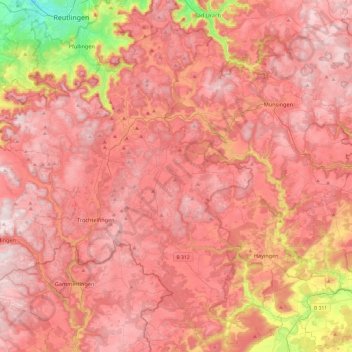
Name: Hohenstein topographic map, elevation, terrain.
Average elevation: 2,333 ft
Minimum elevation: 1,093 ft
Maximum elevation: 2,953 ft
Make a donation
Gear up for your next adventure:
As an Amazon Associate, this site earns from qualifying purchases at no extra cost to you.
Other topographic maps
Click on a map to view its topography, its elevation and its terrain.
Lichtenstein
Germany > Baden-Württemberg > Landkreis Reutlingen
The municipality (Gemeinde) of Lichtenstein covers 34.24 square kilometres (13.22 sq mi) of the Reutlingen district, in the state of the Federal Republic of Germany. It is physically located in the middle of the Swabian Jura, on the edge of the Middle Kuppenalb [de] in the valley of the river Echaz. Elevation…
Average elevation: 2,260 ft
Hülben
Germany > Baden-Württemberg > Landkreis Reutlingen
The Hülben stalactite cave was discovered during the construction of national road Bad Urach-Hülben on September 19, 1978, it is a stalactite cave with stalactites and stalagmites. An about 5 m deep shaft leads into the easily accessible part of the cave. This has about room size, but with only partial low…
Average elevation: 2,188 ft
Make a donation
Gear up for your next adventure:
As an Amazon Associate, this site earns from qualifying purchases at no extra cost to you.