
Port Loring topographic map
Click on the map to display elevation.
About this map
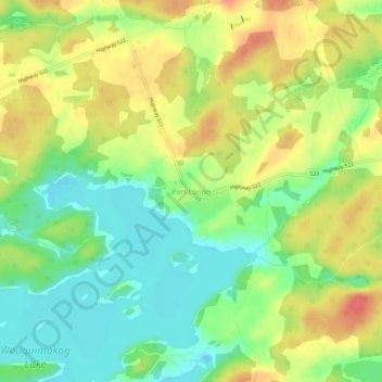
Name: Port Loring topographic map, elevation, terrain.
Average elevation: 745 ft
Minimum elevation: 656 ft
Maximum elevation: 843 ft
Other topographic maps
Click on a map to view its topography, its elevation and its terrain.
Magnetawan River
Canada > Ontario > Parry Sound District > Unorganized Centre Parry Sound
Average elevation: 650 ft
Grundy Lake Provincial Park
Canada > Ontario > Parry Sound District > Unorganized Centre Parry Sound
Average elevation: 646 ft
Pickerel River
Canada > Ontario > Parry Sound District > Unorganized Centre Parry Sound
Average elevation: 656 ft
Harris Lake
Canada > Ontario > Parry Sound District > Unorganized Centre Parry Sound
Average elevation: 686 ft
Ferguson Island
Canada > Ontario > Parry Sound District > Unorganized Centre Parry Sound
Average elevation: 676 ft
Key River
Canada > Ontario > Parry Sound District > Unorganized Centre Parry Sound
Average elevation: 633 ft
Clear Lake
Canada > Ontario > Parry Sound District > Unorganized Centre Parry Sound
Average elevation: 774 ft
Cole Lake
Canada > Ontario > Parry Sound District > Unorganized Centre Parry Sound
Average elevation: 709 ft
Key River
Canada > Ontario > Parry Sound District > Unorganized Centre Parry Sound
Average elevation: 636 ft
Culin Lake
Canada > Ontario > Parry Sound District > Unorganized Centre Parry Sound > Arnstein
Average elevation: 755 ft
Bob's Lake
Canada > Ontario > Parry Sound District > Unorganized Centre Parry Sound
Average elevation: 837 ft
Spring Lake
Canada > Ontario > Parry Sound District > Unorganized Centre Parry Sound
Average elevation: 1,040 ft
Restoule Lake
Canada > Ontario > Parry Sound District > Unorganized Centre Parry Sound
Average elevation: 804 ft
McNeil's Island
Canada > Ontario > Parry Sound District > Unorganized Centre Parry Sound > Port Loring
Average elevation: 699 ft