Geolocate

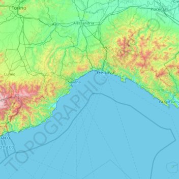
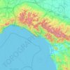
Liguria topographic map

Click on the map to display elevation.

Liguria

The narrow strip of land is bordered by the sea, the Alps and the Apennine Mountains. Some mountains rise above 2,000 m (6,600 ft); the watershed line runs at an average altitude of about 1,000 m (3,300 ft). The highest point of the region is the summit of Monte Saccarello (2,201 m; 7,221 ft).

Wikipedia (CC-BY-SA 3.0)

About this map

Name: Liguria topographic map, elevation, terrain.

Location: Liguria, Italy (43.77569 7.49516 44.67644 10.07151)

Average elevation: 856 ft

Minimum elevation: -3 ft

Maximum elevation: 9,751 ft

Other topographic maps

Click on a map to view its topography, its elevation and its terrain.

Caire di Porcera

Italy > Piedmont > Cuneo > Entracque

Average elevation: 5,016 ft

Mount Vesuvius

Italy > Campania > Naples > Trecase

The volcano's slopes are scarred by lava flows, while the rest are heavily vegetated, with scrub and forests at higher altitudes and vineyards lower down.

Average elevation: 2,828 ft

Temossi

Italy > Liguria > Genoa > Borzonasca

Average elevation: 2,346 ft

Plano

Italy > Piedmont > Turin > Giaglione > San Lorenzo

Average elevation: 2,421 ft

Bruscarolo

Italy > Liguria > La Spezia > Calice al Cornoviglio

Average elevation: 1,421 ft

Tonale

Italy > Lombardy > Brescia > Concesio > Concesio > Casello Pieve

Average elevation: 1,982 ft

Rome

Italy > Lazio > Roma Capitale

Although the city centre is about 24 km (15 mi) inland from the Tyrrhenian Sea, the city territory extends to the shore, where the south-western district of Ostia is located. The altitude of the central part of Rome ranges from 13 m (43 ft) above sea level (at the base of the Pantheon) to 139 m (456 ft) above…

Average elevation: 256 ft
Naples

Italy > Campania > Napoli > Naples

The city is situated on the Gulf of Naples, on the western coast of southern Italy; it rises from sea level to an elevation of 450 metres (1,480 ft). The small rivers which formerly crossed the centre of the city have since been covered over by construction. It lies between two notable volcanic regions, Mount…

Average elevation: 190 ft

Cerisola

Italy > Liguria > Genoa > Rezzoaglio

Average elevation: 3,038 ft

Marinella

Italy > Calabria > Crotone > Crotone

Average elevation: 33 ft

Mount Etna

Italy > Sicily > Catania

During the first 1500 years AD, many eruptions went unrecorded (or records have been lost); among the more significant are: (1) an eruption in about 1030 AD near Monte Ilice on the lower southeast flank, which produced a lava flow that travelled about 10 km, reaching the sea north of Acireale; the villages of…

Average elevation: 3,796 ft

Campanelle-Colle Comune

Italy > Abruzzo > Chieti > Atessa

Average elevation: 390 ft

Calice

Italy > Emilia-Romagna > Parma > Bedonia

Average elevation: 2,982 ft

Cima Portule

Italy > Veneto > Vicenza > Asiago

Cima Portule is a mountain in Italy, located in the province of Vicenza in the Veneto region. It has an elevation of 2,308 metres (7,572 ft).

Average elevation: 6,358 ft
Monte Cengio

Italy > Veneto > Vicenza > Cogollo del Cengio

Monte Cengio is a mountain in the Asiago plateau, within the Vicentine Alps, in Veneto, northeastern Italy. It has an elevation of 1,354 metres and is located on the southwestern edge of the plateau, in the territory of Cogollo del Cengio.

Average elevation: 3,068 ft

Cima di Marana

Italy > Veneto > Vicenza > Recoaro Terme

Average elevation: 3,612 ft

Monte Pulgo

Italy > Veneto > Vicenza > Cornedo Vicentino > Montepulgo

Average elevation: 755 ft

Monte Carafa

Italy > Apulia > Andria

Average elevation: 879 ft

Giovo Ligure

Italy > Liguria > Savona > Pontinvrea

Average elevation: 1,811 ft

Biestro

Italy > Liguria > Savona > Pallare

Average elevation: 1,906 ft

Vasco

Italy > Piedmont > Cuneo > Monastero di Vasco

Average elevation: 1,788 ft

Case Nuove

Italy > Lombardy > Varese > Somma Lombardo

Average elevation: 709 ft

Bardolino

Italy > Veneto > Verona > Bardolino

Average elevation: 371 ft

Isola San Servolo

Italy > Veneto > Venezia > Venice > Lido

Average elevation: 3 ft

Trebbio

Italy > Marche > Pesaro e Urbino > Mercatino Conca

Average elevation: 1,260 ft

Ariana

Italy > Emilia-Romagna > Parma > Traversetolo > Vignale

Average elevation: 653 ft

Case Selvatiche

Italy > Emilia-Romagna > Bologna > Imola > Bicocca Nuova

Average elevation: 72 ft

Poggio Murella

Italy > Tuscany > Grosseto

Average elevation: 1,001 ft

La Condémine

Italy > Aosta Valley > Avise

Average elevation: 4,035 ft

Preggio

Italy > Umbria > Perugia > Umbertide

Average elevation: 1,631 ft

Campolungo

Italy > Emilia-Romagna > Ferrara

Average elevation: -3 ft

Vallerona

Italy > Tuscany > Grosseto

Average elevation: 1,998 ft

Cavolano

Italy > Friuli – Venezia Giulia > Pordenone > Sacile

Average elevation: 75 ft

Montelaguardia

Italy > Umbria > Perugia > Perugia

Average elevation: 1,293 ft

Spignana

Italy > Tuscany > Pistoia > Lizzano Pistoiese

Average elevation: 2,618 ft

Le Breuil - Cervinia

Italy > Aosta Valley

The ski area is very large and guarantees good snow quality during the season, being at a high altitude (2,050 m to 3,500 m).

Average elevation: 7,795 ft
Apennine Mountains

Italy > L'Aquila > L'Aquila

A separate branch, the Apuan Alps, goes southwest, bordering the coast south of La Spezia. Whether they are to be considered part of the Apennines is a matter of opinion; certainly, they are part of the Apennine System. Topographically only the valley of the River Serchio, which running parallel to the coast…

Average elevation: 5,692 ft

Barbiano

Italy > Emilia-Romagna > Parma > Felino

Average elevation: 938 ft

Dossobuono

Italy > Veneto > Verona > Villafranca di Verona

Average elevation: 213 ft

Saccaggio

Italy > Emilia-Romagna > Reggio Emilia > Pontone

Average elevation: 2,021 ft

Marrucheti

Italy > Tuscany > Grosseto

Average elevation: 315 ft

Molinella

Italy > Veneto > Rovigo > Lendinara

Average elevation: 16 ft

Poggio Montone

Italy > Tuscany > Grosseto > Selvena

Average elevation: 2,267 ft

Ossuccio

Italy > Lombardy > Como > Tremezzina

Average elevation: 1,512 ft

Monte Terminillo

Italy > Lazio > Rieti > Micigliano

Monte Terminillo is a massif in the Monti Reatini, part of the Abruzzi Apennine range in central Italy. It is located some 20 km from Rieti and 100 km from Rome and has a highest altitude of 2,217 metres (7,274 ft).

Average elevation: 6,017 ft

Querciola

Italy > Emilia-Romagna > Bologna

Average elevation: 2,493 ft

Chez-les-Fournier

Italy > Aosta Valley > Arvier > Arvier

Average elevation: 3,376 ft

Chia

Italy > Sardinia > Casteddu/Cagliari > Domus De Maria

Average elevation: 177 ft

Pompeii

Italy > Campania > Naples > Pompei

Average elevation: 66 ft

Serre Malan

Italy > Piedmont > Turin > Angrogna

Average elevation: 3,468 ft

Porcile

Italy > Liguria > Genoa > Torriglia

Average elevation: 2,828 ft

Lido del Sole

Italy > Apulia > Foggia

Average elevation: 26 ft

Contrada Mallo

Italy > Abruzzo > Pescara > Penne > Conaprato

Average elevation: 1,132 ft

Montaldo

Italy > Piedmont > Alessandria > Cerrina Monferrato

Average elevation: 778 ft

Corma di Machaby

Italy > Aosta Valley > Arnad

Average elevation: 2,270 ft

Porcile

Italy > Tuscany > Arezzo > Arezzo

Average elevation: 1,808 ft

Monte Campedelle

Italy > Veneto > Belluno > Auronzo di Cadore

Average elevation: 6,834 ft

Gruppo delle Tofane

Italy > Veneto > Belluno > Cortina d'Ampezzo

Average elevation: 6,211 ft

Loreto

Italy > Campania > Benevento > Vitulano

Average elevation: 971 ft

Gualdo

Italy > Tuscany > Lucca > Massarosa

Average elevation: 823 ft

Cinque Terre

Italy > Liguria > La Spezia > Vernazza

Average elevation: 725 ft

Montespluga

Italy > Lombardy > Sondrio > Madesimo

Montespluga is an Alpine village near the head of the Valle Spluga in the Italian region of Lombardy. It is a frazione of the comune of Madesimo, located at 1,908 m of altitude on the road to Chiavenna.

Average elevation: 7,198 ft
Petralia

Italy > Sicily > Messina > Castelmola

Average elevation: 1,145 ft

Pariana

Italy > Tuscany > Lucca > Capornano

Average elevation: 2,113 ft

Regolo

Italy > Lombardy > Lecco > Gittana

Average elevation: 1,388 ft

Neviglie

Italy > Piedmont > Cuneo > Neviglie

Average elevation: 1,204 ft

Cima Dodici (Ferozzo)

Italy > Veneto > Vicenza > Asiago

Cima Dodici (Italian for "peak 12", in Cimbrian language Freyjoch) is a mountain on the border of Vicenza in Veneto and Trentino in Trentino Alto Adige, northern Italy, south of the village of Borgo Valsugana. It has an elevation of 2,336 metres. and is the highest peak in Vicenza. At 1,874 m prominence, it is…

Average elevation: 6,230 ft
Romanina

Italy > Lazio > Roma Capitale > Rome

Average elevation: 249 ft

Impalata

Italy > Apulia > Bari > Monopoli

Average elevation: 883 ft

Zona Industriale Piane di Falerone

Italy > Marche > Fermo > Piane

Average elevation: 791 ft

Laghi Cime Bianche

Italy > Aosta Valley > Valtournenche

Average elevation: 9,199 ft

Monte Caio

Italy > Emilia-Romagna > Parma > Corniglio

Average elevation: 4,232 ft

Ponte

Italy > Umbria > Terni > Castel dell'Aquila

Average elevation: 1,257 ft

Tagliata

Italy > Emilia-Romagna > Reggio nell'Emilia > Guastalla

Average elevation: 72 ft

Portiglioni

Italy > Tuscany > Grosseto > Puntone di Scarlino

Average elevation: 128 ft

Monte Cielo

Italy > Umbria > Perugia > Sigillo

Average elevation: 3,363 ft

Ponte Abbadesse

Italy > Emilia-Romagna > Forlì-Cesena > Cesena

Average elevation: 203 ft

Pianazze

Italy > Emilia-Romagna > Piacenza > Vernasca

Average elevation: 1,138 ft

Macchia Cerasa

Italy > Umbria > Perugia > Poggiodomo

Average elevation: 4,311 ft

Alpi Orobie Occidentali

Italy > Lombardy > Sondrio

Average elevation: 4,022 ft

San Genesio

Italy > Lombardy > Pavia > San Genesio ed Uniti

Average elevation: 279 ft

Impalata

Italy > Apulia > Bari > Monopoli

Average elevation: 883 ft

Albera

Italy > Veneto > Rovigo > Ceneselli

Average elevation: 26 ft

Capitoline Hill

Italy > Lazio > Roma Capitale > Rome

Average elevation: 128 ft

Messena

Italy > Umbria > Perugia > San Giustino

Average elevation: 2,067 ft

Maiella

Italy > Molise > Campobasso > Bojano

Average elevation: 2,126 ft

Gear up for your next adventure:

🏫Relief Map Kits - Hands-on tools for teaching landforms and elevation
📶Vehicle Signal Boosters - Improve reception in rural areas while driving to trailheads
🔋Solar Power Banks - Keep your GPS and phone charged in remote wilderness areas
🪶Camp Gear Gift Set - Perfect gift bundle for outdoor fans
🪶Compact Camp Shovel - Folding shovel for campsite tasks

As an Amazon Associate, this site earns from qualifying purchases at no extra cost to you.