Geolocate

Charleston topographic map

Click on the map to display elevation.

About this map

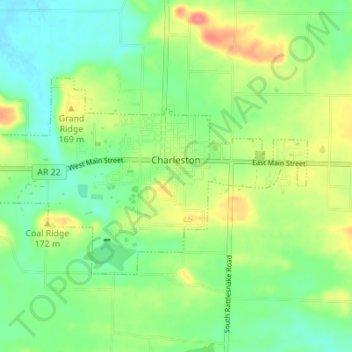
Name: Charleston topographic map, elevation, terrain.

Location: Charleston, Franklin County, Arkansas, United States (35.27889 -94.07970 35.31026 -94.01100)

Average elevation: 512 ft

Minimum elevation: 430 ft

Maximum elevation: 643 ft

Franklin County trails, hiking, mountain biking, running and outdoor activities

Other topographic maps

Click on a map to view its topography, its elevation and its terrain.

Alix

United States > Arkansas > Franklin County

Average elevation: 423 ft

Cecil

United States > Arkansas > Franklin County

Average elevation: 764 ft

Peanut

United States > Arkansas > Franklin County

Average elevation: 1,220 ft

Vesta

United States > Arkansas > Franklin County

Average elevation: 482 ft

Webb City

United States > Arkansas > Franklin County

Average elevation: 443 ft

Mountain Top

United States > Arkansas > Franklin County

Average elevation: 1,575 ft

Redding

United States > Arkansas > Franklin County > Redding

Average elevation: 1,010 ft

Gear up for your next adventure:

🪓Survival Multi‑Tool - Versatile tool for camp and trail tasks
📷Action Camera - Capture your outdoor adventures in HD
🏥Hiking First Aid Kits - Comprehensive medical kits for remote trail injuries
🚑Emergency Bivvies - Heat-reflective sleeping bags for survival situations
🪵Folding Camp Saw - Compact saw for wood and campsite work

As an Amazon Associate, this site earns from qualifying purchases at no extra cost to you.