
Make a donation
Gear up for your next adventure:
As an Amazon Associate, this site earns from qualifying purchases at no extra cost to you.
Ingenried topographic map
Click on the map to display elevation.
Make a donation
Gear up for your next adventure:
As an Amazon Associate, this site earns from qualifying purchases at no extra cost to you.
Ingenried
Ingenried liegt in der Region Oberland am Westrand des Pfaffenwinkels auf rund 800 m Höhe.
Make a donation
Gear up for your next adventure:
As an Amazon Associate, this site earns from qualifying purchases at no extra cost to you.
About this map
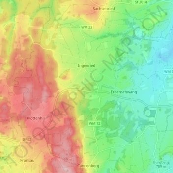
Name: Ingenried topographic map, elevation, terrain.
Average elevation: 2,667 ft
Minimum elevation: 2,388 ft
Maximum elevation: 3,022 ft
Make a donation
Gear up for your next adventure:
As an Amazon Associate, this site earns from qualifying purchases at no extra cost to you.
Other topographic maps
Click on a map to view its topography, its elevation and its terrain.
Make a donation
Gear up for your next adventure:
As an Amazon Associate, this site earns from qualifying purchases at no extra cost to you.
Make a donation
Gear up for your next adventure:
As an Amazon Associate, this site earns from qualifying purchases at no extra cost to you.
Make a donation
Gear up for your next adventure:
As an Amazon Associate, this site earns from qualifying purchases at no extra cost to you.
Staltannen
Deutschland > Bayern > Landkreis Weilheim-Schongau > Lauterbach
Average elevation: 2,654 ft
Grönenbach
Deutschland > Bayern > Landkreis Weilheim-Schongau > Bernbeuren
Average elevation: 2,510 ft
Fahrenberg
Deutschland > Bayern > Landkreis Weilheim-Schongau > Schwabsoien
Average elevation: 2,615 ft
Make a donation
Gear up for your next adventure:
As an Amazon Associate, this site earns from qualifying purchases at no extra cost to you.
Weilheim in Oberbayern
Deutschland > Bayern > Landkreis Weilheim-Schongau > Weilheim in Oberbayern
Average elevation: 1,916 ft
Hoher Peißenberg
Deutschland > Bayern > Landkreis Weilheim-Schongau > Hohenpeißenberg
Der Hohe Peißenberg gehört in der naturräumlichen Haupteinheitengruppe Subalpines Jungmoränenland (Nr. 03), in der Haupteinheit Ammer-Loisach-Isar-Jungmoränenland (037) und in der Untereinheit Hügel- und Moorland des Ammersees (037.0) zum Naturraum Peißenbergkämme (037.09). Seine Landschaft fällt etwa…
Average elevation: 2,657 ft
Make a donation
Gear up for your next adventure:
As an Amazon Associate, this site earns from qualifying purchases at no extra cost to you.
Lexe
Deutschland > Bayern > Landkreis Weilheim-Schongau > Peiting > Herzogsägmühle
Average elevation: 2,346 ft
Make a donation
Gear up for your next adventure:
As an Amazon Associate, this site earns from qualifying purchases at no extra cost to you.
Herzogsägmühle
Deutschland > Bayern > Landkreis Weilheim-Schongau > Peiting
Average elevation: 2,369 ft
Make a donation
Gear up for your next adventure:
As an Amazon Associate, this site earns from qualifying purchases at no extra cost to you.
Vogelfreistätte Ammersee-Südufer
Deutschland > Bayern > Landkreis Weilheim-Schongau > Aidenried
Average elevation: 1,759 ft
Make a donation
Gear up for your next adventure:
As an Amazon Associate, this site earns from qualifying purchases at no extra cost to you.
Make a donation
Gear up for your next adventure:
As an Amazon Associate, this site earns from qualifying purchases at no extra cost to you.
Rameck
Deutschland > Bayern > Landkreis Weilheim-Schongau > Huglfing > Huglfing > Rameck
Average elevation: 2,037 ft
Ficht
Deutschland > Bayern > Landkreis Weilheim-Schongau > Peißenberg > Ficht
Average elevation: 1,923 ft
Make a donation
Gear up for your next adventure:
As an Amazon Associate, this site earns from qualifying purchases at no extra cost to you.
Steinfall
Deutschland > Bayern > Landkreis Weilheim-Schongau > Hohenpeißenberg
Average elevation: 2,438 ft
Make a donation
Gear up for your next adventure:
As an Amazon Associate, this site earns from qualifying purchases at no extra cost to you.