Geolocate

Asher topographic map

Click on the map to display elevation.

About this map

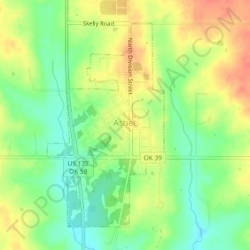
Name: Asher topographic map, elevation, terrain.

Location: Asher, Pottawatomie County, Oklahoma, 74826, United States (34.97841 -96.93399 35.00040 -96.91857)

Average elevation: 1,014 ft

Minimum elevation: 932 ft

Maximum elevation: 1,093 ft

Pottawatomie County trails, hiking, mountain biking, running and outdoor activities

Other topographic maps

Click on a map to view its topography, its elevation and its terrain.

Trousdale

United States > Oklahoma > Pottawatomie County

Average elevation: 997 ft

Macomb

United States > Oklahoma > Pottawatomie County > Macomb

Average elevation: 978 ft

Centerview

United States > Oklahoma > Pottawatomie County

Average elevation: 961 ft

Harjo

United States > Oklahoma > Pottawatomie County

Average elevation: 932 ft

Gear up for your next adventure:

🥤Water Filter Bottle - All‑in‑one filter bottle for safe hydration
🦶Carbon Trekking Poles - Reduce knee impact on steep descents with ultra-light poles
🚑Emergency Bivvies - Heat-reflective sleeping bags for survival situations
🍳Camping Cook Set - Complete cookware for outdoor meals
🛏️Cold Weather Sleeping Bag - Warm sleeping bag for cold conditions

As an Amazon Associate, this site earns from qualifying purchases at no extra cost to you.