
Make a donation
Gear up for your next adventure:
As an Amazon Associate, this site earns from qualifying purchases at no extra cost to you.
Cusubamba topographic map
Click on the map to display elevation.
Make a donation
Gear up for your next adventure:
As an Amazon Associate, this site earns from qualifying purchases at no extra cost to you.
About this map
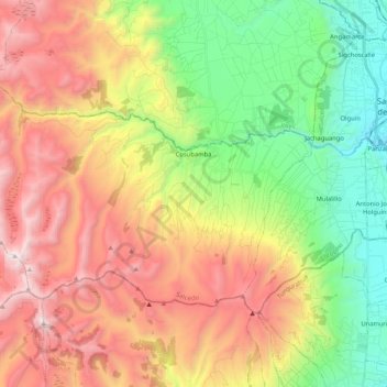
Name: Cusubamba topographic map, elevation, terrain.
Location: Cusubamba, Salcedo, Cotopaxi, Ecuador (-1.15127 -78.84493 -1.03045 -78.63717)
Average elevation: 11,355 ft
Minimum elevation: 8,501 ft
Maximum elevation: 14,875 ft
Make a donation
Gear up for your next adventure:
As an Amazon Associate, this site earns from qualifying purchases at no extra cost to you.
Other topographic maps
Click on a map to view its topography, its elevation and its terrain.
Make a donation
Gear up for your next adventure:
As an Amazon Associate, this site earns from qualifying purchases at no extra cost to you.
Laguna de Yambo
Ecuador > Cotopaxi > Salcedo > Patain > San Jose de Curiquingue
Average elevation: 8,740 ft
Make a donation
Gear up for your next adventure:
As an Amazon Associate, this site earns from qualifying purchases at no extra cost to you.