Make a donation
Gear up for your next adventure:
As an Amazon Associate, this site earns from qualifying purchases at no extra cost to you.
Lipjan topographic map
Click on the map to display elevation.
Make a donation
Gear up for your next adventure:
As an Amazon Associate, this site earns from qualifying purchases at no extra cost to you.
About this map
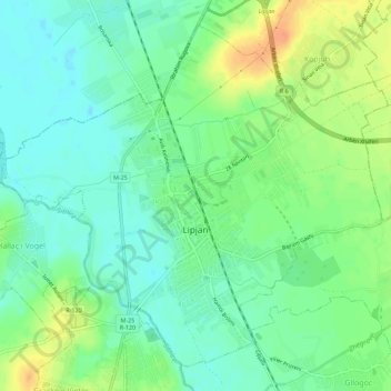
Name: Lipjan topographic map, elevation, terrain.
Location: Lipjan, Municipality of Lipljan, 14000, Kosovo (42.50674 21.09420 42.54295 21.15034)
Average elevation: 1,818 ft
Minimum elevation: 1,772 ft
Maximum elevation: 1,896 ft
Make a donation
Gear up for your next adventure:
As an Amazon Associate, this site earns from qualifying purchases at no extra cost to you.
Other topographic maps
Click on a map to view its topography, its elevation and its terrain.
Make a donation
Gear up for your next adventure:
As an Amazon Associate, this site earns from qualifying purchases at no extra cost to you.
Make a donation
Gear up for your next adventure:
As an Amazon Associate, this site earns from qualifying purchases at no extra cost to you.
Make a donation
Gear up for your next adventure:
As an Amazon Associate, this site earns from qualifying purchases at no extra cost to you.
Make a donation
Gear up for your next adventure:
As an Amazon Associate, this site earns from qualifying purchases at no extra cost to you.
Make a donation
Gear up for your next adventure:
As an Amazon Associate, this site earns from qualifying purchases at no extra cost to you.
Make a donation
Gear up for your next adventure:
As an Amazon Associate, this site earns from qualifying purchases at no extra cost to you.
Bogë
Bogë is a small mountainous village and also a holiday resort village in western Kosovo. Bogë is located in the Bjeshket e Nemuna (cursed mountains on Albanian Alps) mountain range on an altitude of about 1,300m - 1,400m. Nearby the village is located the peak of Hajla at 2,403m and the Bistrica e Pejës…
Average elevation: 5,046 ft
