
Make a donation
Gear up for your next adventure:
As an Amazon Associate, this site earns from qualifying purchases at no extra cost to you.
Eagle Harbor topographic map
Click on the map to display elevation.
Make a donation
Gear up for your next adventure:
As an Amazon Associate, this site earns from qualifying purchases at no extra cost to you.
About this map
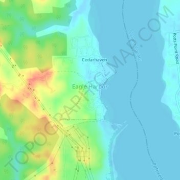
Name: Eagle Harbor topographic map, elevation, terrain.
Average elevation: 43 ft
Minimum elevation: -7 ft
Maximum elevation: 154 ft
Prince George's County trails, hiking, mountain biking, running and outdoor activities
Make a donation
Gear up for your next adventure:
As an Amazon Associate, this site earns from qualifying purchases at no extra cost to you.
Other topographic maps
Click on a map to view its topography, its elevation and its terrain.
Wildercroft
United States > Maryland > Prince George's County > East Riverdale
Average elevation: 128 ft
Make a donation
Gear up for your next adventure:
As an Amazon Associate, this site earns from qualifying purchases at no extra cost to you.
White Hall Terrace
United States > Maryland > Prince George's County > Accokeek
Average elevation: 194 ft
Upper Marlboro
United States > Maryland > Prince George's County > Upper Marlboro > Upper Marlboro
Average elevation: 89 ft
Make a donation
Gear up for your next adventure:
As an Amazon Associate, this site earns from qualifying purchases at no extra cost to you.
Lake Artemesia
United States > Maryland > Prince George's County > College Park
Average elevation: 85 ft
Chestnut Hills
United States > Maryland > Prince George's County > Beltsville
Average elevation: 154 ft
Make a donation
Gear up for your next adventure:
As an Amazon Associate, this site earns from qualifying purchases at no extra cost to you.
Andrews Manor
United States > Maryland > Prince George's County > Camp Springs
Average elevation: 259 ft
Hyattsville
United States > Maryland > Prince George's County
Downtown Hyattsville underwent revitalization in the early 2000s with the development of Arts District Hyattsville, part of the Gateway Arts District, a private project which includes townhomes, live-work units, and retail space. The master developer of the 25-acre neighborhood was Bethesda-based EYA, and was…
Average elevation: 200 ft
Make a donation
Gear up for your next adventure:
As an Amazon Associate, this site earns from qualifying purchases at no extra cost to you.
Auth Village
United States > Maryland > Prince George's County > Camp Springs
Average elevation: 253 ft
Make a donation
Gear up for your next adventure:
As an Amazon Associate, this site earns from qualifying purchases at no extra cost to you.
District Heights
United States > Maryland > Prince George's County > District Heights > District Heights
Average elevation: 240 ft
Make a donation
Gear up for your next adventure:
As an Amazon Associate, this site earns from qualifying purchases at no extra cost to you.
Piscataway
United States > Maryland > Prince George's County > Fort Washington
Average elevation: 118 ft
Greater Capitol Heights
United States > Maryland > Prince George's County > Maryland Park > Greater Capitol Heights
Average elevation: 194 ft
Seabrook Acres
United States > Maryland > Prince George's County > Seabrook > Seabrook Acres
Average elevation: 164 ft
Make a donation
Gear up for your next adventure:
As an Amazon Associate, this site earns from qualifying purchases at no extra cost to you.
Mount Rainier Community Food Forest
United States > Maryland > Prince George's County > Mount Rainier
Average elevation: 75 ft