
Fort Washington topographic map
Click on the map to display elevation.
About this map
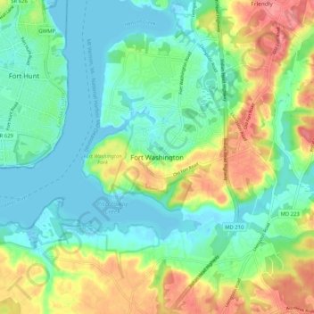
Name: Fort Washington topographic map, elevation, terrain.
Average elevation: 102 ft
Minimum elevation: -10 ft
Maximum elevation: 266 ft
Prince George's County trails, hiking, mountain biking, running and outdoor activities
Other topographic maps
Click on a map to view its topography, its elevation and its terrain.
University Park
United States > Maryland > Prince George's County > University Park
University Park was developed on land owned by the Deakins family since the mid-1700s. The house known as Deakins Hall or Bloomfield was constructed on the land in the 1820s or 1830s. It is located at 6404 Queens Chapel Road. The farm was purchased by the University Park Company in 1923. The extension of water…
Average elevation: 95 ft
Lake Artemesia
United States > Maryland > Prince George's County > College Park
Average elevation: 85 ft
Mount Rainier Community Food Forest
United States > Maryland > Prince George's County > Mount Rainier
Average elevation: 75 ft
Rosaryville State Park
United States > Maryland > Prince George's County > Upper Marlboro
Average elevation: 194 ft
Camp Springs
United States > Maryland > Prince George's County > Camp Springs
Average elevation: 236 ft