Dry Branch topographic map
Interactive map
Click on the map to display elevation.
About this map
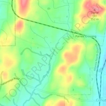
Name: Dry Branch topographic map, elevation, terrain.
Location: Dry Branch, Whitfield County, Georgia, 30710, United States (34.97062 -84.96851 34.97232 -84.96767)
Average elevation: 965 ft
Minimum elevation: 846 ft
Maximum elevation: 1,138 ft
Other topographic maps
Click on a map to view its topography, its elevation and its terrain.
Potato Hill Civil War Battlefield Park
United States > Georgia > Whitfield County > Dalton
Potato Hill Civil War Battlefield Park, 2261, Dalton, Whitfield County, Georgia, 30721, United States
Average elevation: 843 ft
Dalton
United States > Georgia > Whitfield County
Dalton, Whitfield County, Georgia, United States
Average elevation: 833 ft
Varnell
United States > Georgia > Whitfield County
Varnell, Whitfield County, Georgia, 30756, United States
Average elevation: 883 ft
Dalton
United States > Georgia > Whitfield County > Dalton > Dalton
Dalton, Whitfield County, Georgia, 30720, United States
Average elevation: 843 ft
Cohutta
United States > Georgia > Whitfield County
Cohutta, Whitfield County, Georgia, United States
Average elevation: 883 ft