
Make a donation
Gear up for your next adventure:
As an Amazon Associate, this site earns from qualifying purchases at no extra cost to you.
Friuli-Venezia Giulia topographic map
Click on the map to display elevation.
Make a donation
Gear up for your next adventure:
As an Amazon Associate, this site earns from qualifying purchases at no extra cost to you.
Friuli-Venezia Giulia
To the west, the coast is shallow and sandy, with numerous tourist resorts and the lagoons of Grado and Marano Lagunare. To the east, the coastline rises into cliffs, where the Karst Plateau meets the Adriatic, all the way to Trieste and Muggia on the border with Slovenia. The Carso has geological features and phenomena such as hollows, cave networks, and underground rivers, which extend inland in the provinces of Trieste and Gorizia, with an altitude ranging between 300m and 600m.
Make a donation
Gear up for your next adventure:
As an Amazon Associate, this site earns from qualifying purchases at no extra cost to you.
About this map
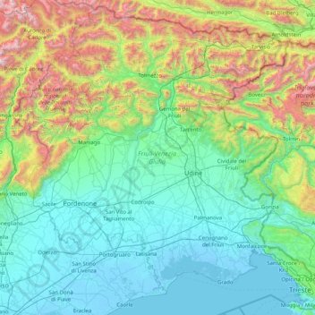
Name: Friuli-Venezia Giulia topographic map, elevation, terrain.
Location: Friuli-Venezia Giulia, Italy (45.58090 12.32138 46.64795 13.91866)
Average elevation: 1,929 ft
Minimum elevation: -16 ft
Maximum elevation: 10,079 ft
Make a donation
Gear up for your next adventure:
As an Amazon Associate, this site earns from qualifying purchases at no extra cost to you.
Other topographic maps
Click on a map to view its topography, its elevation and its terrain.
Make a donation
Gear up for your next adventure:
As an Amazon Associate, this site earns from qualifying purchases at no extra cost to you.
Make a donation
Gear up for your next adventure:
As an Amazon Associate, this site earns from qualifying purchases at no extra cost to you.
Mount Vesuvius
Italy > Campania > Naples > Trecase
The volcano's slopes are scarred by lava flows, while the rest are heavily vegetated, with scrub and forests at higher altitudes and vineyards lower down.
Average elevation: 2,828 ft
Borgnis - Borgne
Italy > Friuli-Venezia Giulia > Udine > Tarcento > Ciseriis
Average elevation: 1,365 ft
Make a donation
Gear up for your next adventure:
As an Amazon Associate, this site earns from qualifying purchases at no extra cost to you.
Make a donation
Gear up for your next adventure:
As an Amazon Associate, this site earns from qualifying purchases at no extra cost to you.
Make a donation
Gear up for your next adventure:
As an Amazon Associate, this site earns from qualifying purchases at no extra cost to you.
Vetzan - Vezzano
Italy > Trentino-Alto Adige/Südtirol > South Tyrol > Schlanders - Silandro
Average elevation: 3,209 ft
Make a donation
Gear up for your next adventure:
As an Amazon Associate, this site earns from qualifying purchases at no extra cost to you.
Laimburg - Castel Varco
Italy > Trentino-Alto Adige/Südtirol > South Tyrol > Vadena - Pfatten
Average elevation: 1,053 ft
Muls
Italy > Trentino-Alto Adige/Südtirol > South Tyrol > Sarntal - Sarentino
Average elevation: 5,505 ft
Make a donation
Gear up for your next adventure:
As an Amazon Associate, this site earns from qualifying purchases at no extra cost to you.
Rolle Pass
Italy > Trentino – Alto Adige/Südtirol > Provincia di Trento > San Martino di Castrozza
Due to altitude, the climate is subarctic (Köppen: Dfc), similar to other high mountains in the Alps. The annual average temperature is 3.2 °C (37.8 °F), the hottest month in July is 11.8 °C (53.2 °F), and the coldest month is −4.4 °C (24.1 °F) in February. The annual precipitation is 1,004.11…
Average elevation: 6,549 ft
Make a donation
Gear up for your next adventure:
As an Amazon Associate, this site earns from qualifying purchases at no extra cost to you.
Make a donation
Gear up for your next adventure:
As an Amazon Associate, this site earns from qualifying purchases at no extra cost to you.
Make a donation
Gear up for your next adventure:
As an Amazon Associate, this site earns from qualifying purchases at no extra cost to you.
San Rocco Castagnaretta
Italy > Piedmont > Cuneo > Cuneo > San Rocco Castagnaretta
Average elevation: 1,867 ft
Urban
Italy > Trentino-Alto Adige/Südtirol > Unsere Liebe Frau im Walde-St. Felix - Senale-San Felice > Unsere Liebe Frau im Walde - Senale > Urban
Average elevation: 5,020 ft
Make a donation
Gear up for your next adventure:
As an Amazon Associate, this site earns from qualifying purchases at no extra cost to you.
Baldal
Italy > Trentino-Alto Adige/Südtirol > Provincia di Trento > Palù del Fersina - Palai en Bersntol > Palai en Bersntol - Palù del Fersina
Average elevation: 5,768 ft
Make a donation
Gear up for your next adventure:
As an Amazon Associate, this site earns from qualifying purchases at no extra cost to you.
Palette
Italy > Trentino-Alto Adige/Südtirol > Provincia di Trento > Spiazzo
Average elevation: 5,623 ft
Make a donation
Gear up for your next adventure:
As an Amazon Associate, this site earns from qualifying purchases at no extra cost to you.