
Make a donation
Gear up for your next adventure:
As an Amazon Associate, this site earns from qualifying purchases at no extra cost to you.
Piedmont topographic map
Click on the map to display elevation.
Make a donation
Gear up for your next adventure:
As an Amazon Associate, this site earns from qualifying purchases at no extra cost to you.
About this map
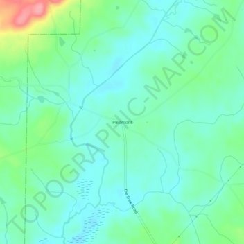
Name: Piedmont topographic map, elevation, terrain.
Location: Piedmont, Lamar County, Georgia, 30285, United States (32.99707 -84.27075 33.03707 -84.23075)
Average elevation: 738 ft
Minimum elevation: 653 ft
Maximum elevation: 1,004 ft
Lamar County trails, hiking, mountain biking, running and outdoor activities
Make a donation
Gear up for your next adventure:
As an Amazon Associate, this site earns from qualifying purchases at no extra cost to you.
Other topographic maps
Click on a map to view its topography, its elevation and its terrain.
Barnesville
United States > Georgia > Lamar County
Barnesville sits on a low ridge at an elevation of 850 feet (260 m) above sea level. Hog Mountain rises above the city to the north, with a summit elevation of 1,015 feet (309 m). The north side of the city drains via Big Towaliga Creek to the Little Towaliga River, the Towaliga River, and eventually the…
Average elevation: 810 ft
Make a donation
Gear up for your next adventure:
As an Amazon Associate, this site earns from qualifying purchases at no extra cost to you.