
Make a donation
Gear up for your next adventure:
As an Amazon Associate, this site earns from qualifying purchases at no extra cost to you.
Tafea topographic map
Click on the map to display elevation.
Make a donation
Gear up for your next adventure:
As an Amazon Associate, this site earns from qualifying purchases at no extra cost to you.
Tafea
The island of Tanna has the world's most accessible volcano, Mount Yasur, with 1,084 meters the highest peak of the province. Aniwa Island is the only coral island, the other four are volcanic and reach much higher elevations than Aniwa.
Make a donation
Gear up for your next adventure:
As an Amazon Associate, this site earns from qualifying purchases at no extra cost to you.
About this map
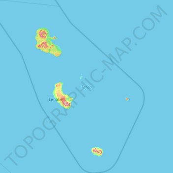
Name: Tafea topographic map, elevation, terrain.
Location: Tafea, Vanuatu (-20.46274 168.35376 -18.27167 170.44998)
Average elevation: 23 ft
Minimum elevation: 0 ft
Maximum elevation: 3,189 ft
Make a donation
Gear up for your next adventure:
As an Amazon Associate, this site earns from qualifying purchases at no extra cost to you.
Other topographic maps
Click on a map to view its topography, its elevation and its terrain.
Make a donation
Gear up for your next adventure:
As an Amazon Associate, this site earns from qualifying purchases at no extra cost to you.
Ambae
Traditional subsistence agriculture satisfies food needs, while most villagers engage in small-scale cash crop production as well. Often grown in large upland gardens (with good rainfall and safe from roving pigs), the primary crops are taro, banana, yam, and manioc. sweet potatoes, vegetables, fruits and nuts…
Average elevation: 574 ft
Make a donation
Gear up for your next adventure:
As an Amazon Associate, this site earns from qualifying purchases at no extra cost to you.
Ambae
Traditional subsistence agriculture satisfies food needs, while most villagers engage in small-scale cash crop production as well. Often grown in large upland gardens (with good rainfall and safe from roving pigs), the primary crops are taro, banana, yam, and manioc. Kumala (sweet potatoes – a good tuber…
Average elevation: 574 ft
Ambae
Traditional subsistence agriculture satisfies food needs, while most villagers engage in small-scale cash crop production as well. Often grown in large upland gardens (with good rainfall and safe from roving pigs), the primary crops are taro, banana, yam, and manioc. sweet potatoes, vegetables, fruits and nuts…
Average elevation: 574 ft
Make a donation
Gear up for your next adventure:
As an Amazon Associate, this site earns from qualifying purchases at no extra cost to you.
Tongoa
Vanuatu > Shefa Province > Euta
Tongoa is the largest island of Shepherd Islands archipelago. The island is heavily vegetated and shows geothermal activity. Tongoa is of recent volcanic origin but currently has no currently active volcano. There are numerous volcanic cones on the island and some black sand beaches. The estimated terrain…
Average elevation: 292 ft
Make a donation
Gear up for your next adventure:
As an Amazon Associate, this site earns from qualifying purchases at no extra cost to you.