Geolocate

Munising Township topographic map

Click on the map to display elevation.

About this map

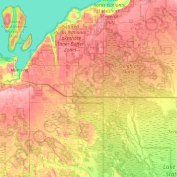
Name: Munising Township topographic map, elevation, terrain.

Location: Munising Township, Alger County, Michigan, United States (46.15856 -86.67866 46.57226 -86.36470)

Average elevation: 801 ft

Minimum elevation: 571 ft

Maximum elevation: 1,047 ft

Alger County trails, hiking, mountain biking, running and outdoor activities

Other topographic maps

Click on a map to view its topography, its elevation and its terrain.

Christmas

United States > Michigan > Alger County

Average elevation: 666 ft

Kiva

United States > Michigan > Alger County

Average elevation: 1,017 ft

Indian Town

United States > Michigan > Alger County

Average elevation: 886 ft

Ice

United States > Michigan > Alger County

Average elevation: 741 ft

Gear up for your next adventure:

🌲Outdoor Survival Books - Best books on survival skills
🪄Magnetic Compass - Accurate compass for navigation
📻Weather Alert Radios - Stay informed of storm risks while off-the-grid
📡GPS Antenna Upgrade - Enhance GPS reception in remote terrain
💧Water Purification System - Clean water on the trail with reliable purifiers

As an Amazon Associate, this site earns from qualifying purchases at no extra cost to you.