Geolocate

Alipur Tehsil topographic map

Click on the map to display elevation.

About this map

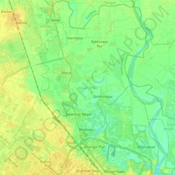
Name: Alipur Tehsil topographic map, elevation, terrain.

Location: Alipur Tehsil, North Delhi, Delhi, India (28.70401 77.08408 28.86313 77.22367)

Average elevation: 696 ft

Minimum elevation: 663 ft

Maximum elevation: 728 ft

Other topographic maps

Click on a map to view its topography, its elevation and its terrain.

D1 Janakpuri Park

India > Delhi > New Delhi

Average elevation: 719 ft

M Block Market

India > Delhi > Kalkaji Tehsil

Average elevation: 735 ft

Mehrauli

India > Delhi > Mehrauli Tehsil > Mehrauli

Average elevation: 830 ft

Narela

India > Delhi > Narela Tehsil

Average elevation: 712 ft

Samaspur

India > Delhi > Mayur Vihar Tehsil > Samaspur

Average elevation: 673 ft

Hauz Rani

India > Delhi > Hauz Khas Tehsil

Average elevation: 755 ft

Gear up for your next adventure:

🔭Stargazing Telescopes - Perfect for camping in low-light pollution areas shown on maps
🔥Fast-Boil Camping Stoves - Efficient cooking systems for quick trail meals
🦶Hiking Gaiters - Keep debris and water out of your boots
Solar GPS Watches - Advanced multisport watches with built-in topographic maps
Backpacking Tents - Weight-optimized shelters for multi-day topographic surveys

As an Amazon Associate, this site earns from qualifying purchases at no extra cost to you.