Geolocate

Setiu topographic map

Click on the map to display elevation.

About this map

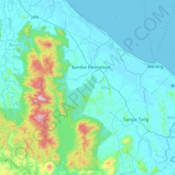
Name: Setiu topographic map, elevation, terrain.

Location: Setiu, Terengganu, Malaysia (5.18771 102.58928 5.72785 103.00127)

Average elevation: 564 ft

Minimum elevation: -10 ft

Maximum elevation: 4,921 ft

Other topographic maps

Click on a map to view its topography, its elevation and its terrain.

Kampung Pasir Akar

Malaysia > Terengganu

Average elevation: 66 ft

Kampung Tanah Merah

Malaysia > Terengganu

Average elevation: 30 ft

Paka

Malaysia > Terengganu > Dungun

Average elevation: 33 ft

Keruak

Malaysia > Terengganu

Average elevation: 272 ft

Sungai Nerus

Malaysia > Terengganu > Kampung Jeram Hilir

Average elevation: 56 ft

Jerteh

Malaysia > Terengganu

Average elevation: 39 ft

Batu Rakit

Malaysia > Terengganu > Batu Rakit

Average elevation: 69 ft

Gear up for your next adventure:

☀️Outdoor Sunscreen - High protection sunscreen for outdoor activities
🔋Solar Power Banks - Keep your GPS and phone charged in remote wilderness areas
📦Gear Storage Bags - Organize and protect outdoor equipment
🥾Hiking Shoes - Durable and comfortable shoes for trail hiking
🚗GPS Dash Cams - Record your scenic drives through mountain passes and canyons

As an Amazon Associate, this site earns from qualifying purchases at no extra cost to you.